|
|
|
Railroad Stations
By H. Schile |
|
Rondout |
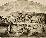
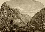
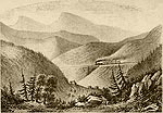
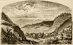
RONDOUT.
RONDOUT possesses a remarkably pretty little port, which carries on considerable traffic, since it owns about thirty small steamers.
This port is situated between two mountains. The city lies to the right, while on the left can be seen a beautiful landscape, dotted all over with pretty little cottages. The streets of the city are very irregular and steep. They extend as far as Kingston, which village, with Rondout, now forms the city of Kingston.
|
|
Right in front of the mountain is a cement mine, which is a source of interest to the visitor. Several brick-kilns are also situated near by. Rondout is chiefly noted for her extensive commerce in coal, limestone and cement, and every year this industry is becoming more extensive.
At this point the railroad through the Catskills begins. Here is the first steep grade of the railway, which extends to the highest point, viz : the Summit.
Kingston lies on the western banks of the Hudson. The city was founded by the Dutch, about two hundred years ago. Three times it was burned to the ground by the Indians, from whose depredations it suffered severely. But the Dutch were alone responsible for the hatred of the Indians, for cunning and cruelty marked all their dealings with
the red man. In the year 1777, three thousand British soldiers, led by General Vaughan, ransacked the city.
The old adage, "the mountains are the hearth of liberty" proved true again, for the people in this region were full of love and devotion to the cause of freedom! Here,
where the first State Constitution was drawn up, and where the first State Legislature convened, met also his death the first British spy captured on American soil. A carries
of a dispatch from Clinton proved a traitor, but lie divulged his infamous secret to a loyal heart ; the spy was arrested, and expiated his crime on the scaffold.
|
|
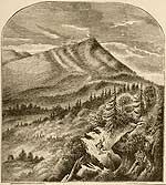
OVERLOOK MOUNTAIN. Elevation 3,140 ft. |
WEST HURLEY STATION.
This is the first station on the way to the Overlook Mountain House.
It is elevated about 540 feet. A beautiful pathway leads from here through Woodstock, and thence up hill to Mead's House. From Mead's House we can obtain a wonderfully picturesque view in all directions. In the back-ground rise the Twin Mountains and Indian Heads. From Mead's House a steady up-hill road leads through the forest directly to the Overlook Mountain House, and from here, a bird's-eye view of the surrounding country can be had. The Hotel is situated right in front of the lofty peak of the first mountain, thus affording a view of all the country below, as well as the distant Hudson Highlands. In clear weather, the scenic effects are grand beyond description. From West Hurley Station, the Overlook Mountain House is plainly visible, it being on an elevation of 3,150 feet.
|
The next station, about three miles distant, is Olive Branch, the principal station for the neighboring farmers. It lies at an elevation of 511 feet.
BROWN'S STATION.
It is about fifteen miles from the Hudson shore, and is situated at a height of about 525 feet above high water-mark. It is only within six years that this neighborhood has been visited as a summer resort. Mr. Lasher began at that time with four boarders. Last year he had over fifty guests. This increase alone is sufficient evidence of the • popularity of the place.
Not far from Mr. Lasher's, are his neighbors, Messrs. Stratton, Dietrich & Brown, near the station. This neighborhood is well adapted for organizing flying trips into the Catskills, for it contains excellent pathways, which run in all directions and, from its central position, requires no traveling of any consequence.
BROADHEAD'S BRIDGE STATION.
This station, being the next in order, is about 500 feet above the level of the sea, and at a distance of about seventeen miles from the Hudson, and one mile and a half from Bishop's Falls.
SHOKAN STATION,
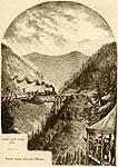
About nineteen miles from the Hudson, and 533 feet above the water level. This is one of the most important of all the stations along the line. It is the central point, where the railroad makes a sharp turn towards the right, and to the left of which rises the highest mountains. It is very appropriately called the "Inlet into the mountains."
BOICEVILLE STATION
Has an elevation of about 590 feet. The valley is quite narrow here.
|
|
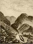
View Between Phoenicia And Fox Hollow
Woodland Valley, From Mount Wittenberg
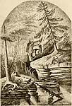
Esopus Creek
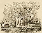
The Old Butternut Tree At Shandaken Station
|
MOUNT PLEASANT STATION.
This lies about 24. miles from the Hudson, and is 690 feet high. The station is in the centre of Mount Pleasant, and opposite to it is Tremper Mountain.
Mount Pleasant is one of the longest of the Catskill Mountains, extending, as it does, from Boiceville to the Woodland Valley, where it shuts out all further inroads to the beautiful mountains. Mount Pleasant has several very pretty boarding houses, for example, that of Mr. Schumacher's formerly called the "Corner;" situated on the height; and that of Mrs. Lamson.
PHOENICIA STATION
Lies about 27 miles from the Hudson, and has an elevation of 790 feet. It is a central station, from which to make trips into the gorgeous. mountains and beautiful valleys. Just opposite the station, is the well known Tremper House. This affords as picturesque a view as any European watering place could impart. A short distance from, and to the left of the station is found the Woodland Valley, lying between Phoenicia Station and Fox Hollow. Mount Sheridan looms up directly in front; to the right you may see Mount Tremper; to the left, Mount Romer, and in the distance, Panther Mountain. On the road to the Stony Clove, we pass the Tremper House, and arrive at Chichester which is so celebrated for its chair manufacturies. The distance from Phoenicia to Stony Clove is about 11 miles. A pretty pathway through the valley, leads to it.
Passing Stony Clove, the road branches to the right and to the left. The former branch goes to Tannersville, the latter to Hunter Green County.
FOX HOLLOW.
The next station, is 996 feet high, and is the nearest entry to Woodland Valley.
To the left of Shandaken Station, there stands a remarkable butternut tree said to be eighty years old. When but seventy-five years old, it is reported to have yielded a crop of seventy-five bushels of nuts. I had heard so much about the tree that I determined to visit it
but last Fall, on going to see it, I found it bare and naked, and sketched it just as seen at the time. I am told that its shadow covers a surface of eighty five feet. I discovered, also, that in the course of time, an amputation had been performed on the old fellow, to make room for the railroad.
|
|
SHANDAKEN STATION
Is situated about 33 miles from the Hudson, is about 1069 feet above the water level, and lies at the foot of the Panther Mountain. Shandaken is the central point of the Shandaken Valley. There is a path from here to Westkill. The scenic effects produced by the mountains are magnificent.
Before reaching Westkill we pass through the Deep Notch or Deep Hollow. The valbraley extending from Shandaken to Westkill has been named the " Bushnellville Hollow." In these deep narrow straits of the mountains, ice can be found at all times of the year, even in the heat of summer. At the corner of Bushnellville Hollow, there is a fine hotel, known as Lament's Hotel.
|
|
BIG INDIAN. Elevation 1,209 ft.
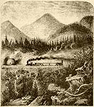
Grand View Between Pine Hill And Big Indian
View From The Guigou House
Pine Hill And Summit - Elevation 1160 ft.
Horse-Shoe Bend, From Pine Hill Station
Griffin's Corners
|
BIG INDIAN STATION
Is situated in the wilderness, thirty six miles from the Hudson, and 1,209 feet above the water level. The Big Indian Valley contains the inlet to Slide Mountain, which rises to the height of 4,230 feet. The distance from the Station, through the valley, to the highest point of Slide Mountain, is about eleven miles. Dutcher, the guide, lives five miles from here.
At Big Indian Station, the railroad turns to the right, where a steep grade combramences, of 145 feet to the mile. After crossing a narrow pass, the railroad runs over a small bridge, thus passing from mountain to mountain. From the Guigou House, located up here, you can obtain a remarkably fine view of the surrounding scenery.
PINE HILL STATION,
Thirty nine miles from the Hudson; 1,660 feet in height, and situated at the end of the valley. This is a charming little village, and no lovelier view of it can be obtained than that from the railway on the mountain above.
Above the Station, the railroad makes a horseshoe turn, thus enabling the traveler to keep Pine Hill constantly in view. Grade, 145 ft. to the mile.
The distance from the Station to the highest point which the cars pass here, is two miles.
The boundary line between Ulster and Delaware Counties also passes through here.
The stream which flows down the mountain, divides, at this point, into two branches. The one running toward Pine Hill, and emptying into the Hudson, is known as the Esopus Creek. The one flowing by Griffin's and Dean's Corners, empties by Margaretville into the East Branch Delaware.
Pine Hill has been for many years a popular summer resort.
The proprietor of the Pine Hill Hotel, Mr Cole, does not claim for it the elegance and beauty of the large New York Hotels, but, under the circumstances, it possesses every comfort desirable, and, the terms being reasonable, is well calculated to please all its patrons
This is the very highest point that the railroad reaches. It is 1,886 feet in height and about two miles distant from Pine Hill.
A few steps and we are at the Grand Hotel ; and even this short walk, leading through such a beautiful, shady pathway, constitutes one of the great attractions of the place.
GRIFFIN'S CORNER
Is forty-four miles from Rondout, and 1,516 feet in height. This is, likewise, a favorite summer resort. It is the first place of its kind in Delaware County, and is about three miles distant from the Summit Mountain. The railroad here makes wonderful turns around the mountains and precipices. The Station is about two miles below the village. It is charmingly located, and one can scarcely imagine anything more charming than the picture of the pretty little village, as seen from the railroad running high above it.
There are many excellent boarding-houses here, prominent among which is Mr. Baler's. This House deserves to be recommended for its appropriate situation and good management.
|
DEAN'S CORNER, OR ARKVILLE.
This is about forty eight miles from the Hudson, and is situated opposite the Pakataghkan Mountain, which rises to the height of 3,000 feet.
Dean's Corner has an elevation of 1,334 feet. The railroad turns to the right here, while the water takes its course to the left, and, at Margaretville, flows into the East Branch Delaware. From here the valleys rise, and continue to do so as far as Stamford. The distance to Margaretville is not over one mile. Mr. Ackerly keeps a very fine hotel and boarding-house there, and omnibusses connect with all trains.
KELLY'S CORNERS.
The Station following is Kelly's Corners, fiftybratwo miles from the Hudson, and 1,374 feet above the water level. A pathway to the right leads through the beautiful Bataviabrakill Valley. The little river, East Branch, (so named from the Delaware), flows from the Grand Gorge, eastward to Margaretville.
HALCOTTVILLE.
Fifty-three miles from the Hudson, and 1,399 feet in height.
This is a remarkably cool place. At the bridge, the stream is broad and well adapted for fishing and rowing.
STRATTON'S FALLS
Is 57 miles from the Hudson, and 1456 feet in height. If you are desirous of seeing the Falls, you will be obliged to turn to the left towards the mountain, which is at a considerable distance from the railroad.
|
|
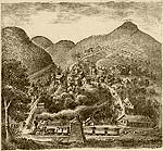
Roxbury
|
ROXBURY
Is 59 miles from the Hudson, and 1497 feet above the level of the sea. It is one of the important stations, and contains many summer boarding houses.
The wide valley is wonderfully pretty, resembling those that are to be seen in the mountainous districts of South Germany.
The main street runs straight through the village, and for a mile at least, it is borbradered with neatly built dwellings and churches, and tastefully arranged gardens. At the end of this long street, the road turns to the right, leading to Grand Gorge.
|
The valley itself is called Montgomery Hollow. This Hollow produces a very peculiar impression upon the eye. The valley having the appearance of a viaduct, is somewhat hilly on the right. We can see the remainder of what was formerly, a mighty forest. The treebrastumps rise to a height of about four and onebrahalf feet, and as they stand there in rows, present a ghostly appearance.
GRAND GORGE, (Moresville.)
Is 65 miles distant from the Hudson, and 1570 feet high. It is one of the most romantic, magnificent, ravines in Delaware County.
|
|
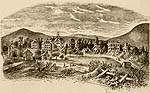
Stamford |
STAMFORD
Is about 74 miles from Rondout, and is situated on a height of 1767 feet. This is the highest village of all those along the railroad.
|
The mountainous district in this vicinity resembles that of Greene County. The mountains themselves do not appear to be so lofty as they are said to be ; but this is due to the fact that the valleys are quite high. To the left of Stamford can be seen the magnificent Mount Utsyanthia Mountain, which rises to a heighth of 3,365 feet. A pretty hotel will be erected on its summit.
This will undoubtedly prove a very popular resort, as it is excellently situated, and is the terminus of the railroad. Two trains come and go daily, thus giving the visitor ample time to view the surrounding country.
|
|
|
|