|
449
 A Railroad in the Clouds —Oroya Railroad A Railroad in the Clouds —Oroya Railroad
Scribner's—Vol. XIV.—29.
IT somewhat surprises the American tourist in Peru that no
detailed description has appeared in the United States of the
great railway over the Andes, especially as it has been the work
of an American. The writer of this account, therefore, takes peculiar
pleasure in introducing the journey to the readers of SCRIBNER'S
MAGAZINE, in the hope, not only
of imparting to others something of the novel enjoyment he himself
experienced in it; but also of presenting some of the most remarkable
difficulties and impressive features of this truly Cyclopean undertaking.
A visit to Peru rewards the traveler with an extensive field
of study and pleasure, in the beauty and grandeur of its scenery,
the variety of its climates and productions, the romance of its
history, and in the archaeological remains that represent its
very ancient civilization. When to these attractions is added
one of the essential elements of modern progress,—easy railroad
communication in its highest development,—it becomes,
450
for this our western world, a land of unequaled interest. The
surface of the country is itself characterized by great variety.
A strip of sandy waste, traversed by streams and fertile valleys,
extends from the Pacific Ocean to the mountains that form a double
barrier between the coast and the Montaña. This barrier,
called the Sierra, consists of two ranges, the Western, or Maritime
Cordillera, and the Andes, or Eastern Cordillera. Between them
are transverse branches, luxuriant tropical valleys, lofty plateaus,
and tablelands of great extent where the Sierra widens out, as
it does about Lake Titicaca. The Montaña comprises two-thirds
of the Peruvian territory, and is a tropical region teeming with
animal and vegetable life, lying wholly in the basin of the Amazon.
The line of the Calláo. Lima and Oroya Railroad stretches
across the coast, and a greater portion of the Sierra. It starts,
as its name specifies, from the very shores of the Pacific, at
Calláo, the port of Lima, and the chief entrepôt
of Peru. It follows the valley of the Rimac, upon a continuously
ascending grade, to the source of that stream, and crosses the
summit of the Andes through a tunnel—the Galera—a height
of 15,645 feet above the level of the sea. Thence, striking the
head-waters of the Rio Yauli, one of the feeders of the Amazon,
it descends along its valley to Oroya, where terminates the first
part of the great road by which it has been proposed to connect
the waters of the Pacific Ocean and the Amazon River, notwithstanding
the formidable obstacles that intervene.
 We take the
train at Lima for our long anticipated and deeply interesting
journey and, following the left bank of the Rimac, find ourselves
traveling through a valley that averages about three miles in
width, until we reach Chosica, where the converging lines of the
Cordillera compress it to a width of little more than 1000 feet.
Owing to the admirable system of irrigation long practiced in
Peru, the land is remarkably fertile, and produces fruits and
cereals in such abundance as to surprise the traveler, since the
region is subject to frequent volcanic disturbance. The road follows
the center of the valley, amid fields green with corn, and sugarcane,
and the nutritious lucern or alfalfa—a species of clover
extensively and profitably cultivated. Between Lima and Chosica
very little difficulty was experienced in the construction of
the road, the principal requirement being a conformity to the
gradual rise of the valley, which was accomplished by the adoption
of a parallel grade, amounting in some cases to two and a half
percent, or 125 feet to the mile. We are told that Chosica is
the most interesting place in the neighborhood of Lima for archaeological
researches; but the train allows no time for investigation, and
we soon exchange the pastoral and picturesque valley for the barren
and precipitous mountain-pass. Green fields are left behind, and
the thorny cactus already begins to dot the sides of the declivities.
The track takes the tortuous course of the Rimac, on whose edge
we pursue a darkening defile. Here the four percent grade begins,
and with it regular up-hill work. We take the
train at Lima for our long anticipated and deeply interesting
journey and, following the left bank of the Rimac, find ourselves
traveling through a valley that averages about three miles in
width, until we reach Chosica, where the converging lines of the
Cordillera compress it to a width of little more than 1000 feet.
Owing to the admirable system of irrigation long practiced in
Peru, the land is remarkably fertile, and produces fruits and
cereals in such abundance as to surprise the traveler, since the
region is subject to frequent volcanic disturbance. The road follows
the center of the valley, amid fields green with corn, and sugarcane,
and the nutritious lucern or alfalfa—a species of clover
extensively and profitably cultivated. Between Lima and Chosica
very little difficulty was experienced in the construction of
the road, the principal requirement being a conformity to the
gradual rise of the valley, which was accomplished by the adoption
of a parallel grade, amounting in some cases to two and a half
percent, or 125 feet to the mile. We are told that Chosica is
the most interesting place in the neighborhood of Lima for archaeological
researches; but the train allows no time for investigation, and
we soon exchange the pastoral and picturesque valley for the barren
and precipitous mountain-pass. Green fields are left behind, and
the thorny cactus already begins to dot the sides of the declivities.
The track takes the tortuous course of the Rimac, on whose edge
we pursue a darkening defile. Here the four percent grade begins,
and with it regular up-hill work.
As we pass the village of San Pedro de Mama, roofless adobe
huts and catacombs in the sides of volcanic ridges are the only
remains of a once thriving population. The narrow valley of Eulalia
then branches to the left, flanked by lofty natural walls, and
open only to a vertical sun, and yet it supplies the market of
Lima with almost every variety of tropical fruit. About this point,
the road passes through "the Italian cut," named for
seventeen wandering Romans, all of whom died in the process of
its construction. Five or six miles beyond Chosica we cross the
first of the iron bridges—Cupiche—that span the gorge,
and we follow the curvatures of the river at a grade of four percent,
or 211 feet per mile. The road conforms with persistent regularity
to the contour of the mountains, crossing and re-crossing the
Rimac, and passing in its course a heavy deposit of gravelly talc,
extensively used in paving the streets of Lima. Thence the valley
widens to Cocachacra, displaying miniature fields of corn and
alfalfa, and gladdening the eyes with an oasis in the midst of
this rocky fastness, until converging mountains shadow the valley,
hem in the impetuous river, to recede again and encircle a bit
of verdure, where the Seco, a mountain stream, empties into
451
 the Rimac.
Looking forward from this point the course of the road can be
distinctly traced, winding along the right declivities of the
ravine, until it approaches tunnel No. 1, discernible four and
a half miles off, at a height of 600 feet above the valley, as
a little dark spot. Seen from such a distance, a train of cars
appears like a great serpent along the face of rocks that are
piled one upon another to the very summit of vanishing heights.
The next station, San Bartolomé, thirty-nine miles from
Lima, is 4,910 feet above the sea—an unparalleled ascent
for that distance. the Rimac.
Looking forward from this point the course of the road can be
distinctly traced, winding along the right declivities of the
ravine, until it approaches tunnel No. 1, discernible four and
a half miles off, at a height of 600 feet above the valley, as
a little dark spot. Seen from such a distance, a train of cars
appears like a great serpent along the face of rocks that are
piled one upon another to the very summit of vanishing heights.
The next station, San Bartolomé, thirty-nine miles from
Lima, is 4,910 feet above the sea—an unparalleled ascent
for that distance.
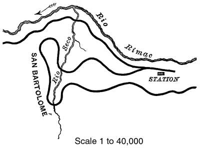
Here occurs the first, of the retrograde developments rendered
necessary by the increasing rise in the valley: The line takes
the form of a V as shown in the diagram, and receding upon an
ascending grade reaches the elevated plateau where stagnates the
forbidding-looking village of San Bartolomé. Thence crossing
and re-crossing the Seco, it makes two complete detours and ascends
on the opposite side, past a point overlooking the station of
San Bartolomé, whence a vista opens into scenery somewhat
Alpine in its character. Yet the road still clings to the rugged
sides of the towering ridges, passes through two tunnels, and
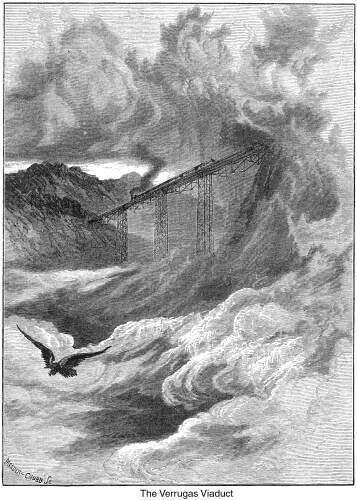
crosses a deep mountain gorge on the famous Verrugas viaduct.
This structure is a very elegant and artistic specimen of iron-work.
It is of the Fink type of truss—575 feet in length, supported
upon three piers of wrought-iron columns or rods, respectively,
145, 252, and 189 feet in height. It is the highest bridge in
the world. And although at a distance it appears too delicate
for the practical work of a railroad, it has been found on being
subjected to the severest tests, capable of bearing the heaviest
weight without any sensible vibration. At the base of the central
pier are huge pits, which treasure-seekers have vainly excavated
in the hope of finding the buried riches of the Incas, concealed,
as it was supposed, from the rapacity of their Spanish conquerors.
452
Leaving this fairy-like viaduct behind us, the road pierces
two projecting bluffs by tunnels Nos. 3 and 4. The former is approached
by a cut in the upper side, about 400 feet in height, against
the face of a precipice (Cuesta Blanca) that rises 1,000 feet
in the air. Along this entire portion of the route, the rails
wind through a great labyrinth of detached rocks and bowlders,
apparently so delicately poised that the most trifling convulsion
might at any moment precipitate them into the valley below. Nevertheless,
the road pursues its course through deep cuts, in spite of all
obstacles, shaping itself to the outline of the 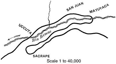 mountains, and ascending with unfaltering
steadiness from height to height, at a grade of 210 feet per mile.
At and above Surco, the valley occasionally expands into little
ovals of bottomland that afford space for the cultivation of a
diminutive field or an occasional flower, sadly solitary in this
volcanic region. A mile further on we cross the Rimac by the Uccuta
bridge, from which there is a view of tunnels Nos. 5, 6, and 7.
The last two are perched directly above No. 5, and appear like
dark drifts or openings in a coal mine. Higher up the valley,
beyond the third tunnel, may be seen the delicate outline of the
Challapa bridge, spanning a deep chasm as if suspended in mid-air.
All these interesting points are speedily reached by two complete
detours. The first crosses the river by the Mayuyaca bridge, and
describes an entire semicircle upon a 14 degree curve of 376 feet
radius; thence passing southward for about a mile to Sacrape.
Here the second detour returns the line on its course to the two
tunnels which we previously saw from below; and when it emerges
from them, it pushes on, mountains, and ascending with unfaltering
steadiness from height to height, at a grade of 210 feet per mile.
At and above Surco, the valley occasionally expands into little
ovals of bottomland that afford space for the cultivation of a
diminutive field or an occasional flower, sadly solitary in this
volcanic region. A mile further on we cross the Rimac by the Uccuta
bridge, from which there is a view of tunnels Nos. 5, 6, and 7.
The last two are perched directly above No. 5, and appear like
dark drifts or openings in a coal mine. Higher up the valley,
beyond the third tunnel, may be seen the delicate outline of the
Challapa bridge, spanning a deep chasm as if suspended in mid-air.
All these interesting points are speedily reached by two complete
detours. The first crosses the river by the Mayuyaca bridge, and
describes an entire semicircle upon a 14 degree curve of 376 feet
radius; thence passing southward for about a mile to Sacrape.
Here the second detour returns the line on its course to the two
tunnels which we previously saw from below; and when it emerges
from them, it pushes on,
453
 crossing Challapa
Gorge on a beautiful bridge, 160 feet high, which a short time
before had appeared to us as an aerial structure. crossing Challapa
Gorge on a beautiful bridge, 160 feet high, which a short time
before had appeared to us as an aerial structure.
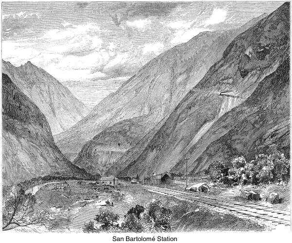
Thence we wind along the hills to Matucana, an important station
thirty-five miles from Lima, and 7,788 feet above the level of
Calláo Bay. The Cordilleras tower above the primitive little
town, to the height of from 3,000 to 4,000 feet. It shelters,
it is said, a thousand inhabitants, and is the gathering place
of as many more "children of the mist," who flock from
the neighboring mountains on the occasion of every excitement,
festival, or anniversary. They are exclusively of the Indian type,
peculiar to this part of South America, and are by no means an
attractive race. In person, they are short and stout, and have
a very sinister expression of countenance. They are sharp and
unscrupulous in their business transactions, irascible and vindictive
in temper, uninteresting and indifferent in their manner to strangers,
and withal, affect an air of stolid superiority as if they were
the veritable descendants of the Incas, and were surrounded by
all the fabulous splendors of their ancestors. Nevertheless, they
live in the usual adobe huts only one story high, whose slanting
roofs are thatchedwith straw; and their wives, with papooses strapped
to their backs, superintend the labors of the house and garden.
The principal men or hidalgos, in wide sombreros and ponchos of
vicuña or other skins, ride about on sure-footed little
horses, or donkeys, that amble in a manner peculiar to the animals
of Chili and Peru. Add these figures to the ordinary accompaniments
of a railway-station, such as busy officials, waiting travelers,
an arriving or departing train, and the village of Matucana is
described.
454
 Borne away from
the fumes and bustle of the unattractive little town, we find
that impressive as has been the scenery through which we have
passed, it has been but the introductory pageant to the gloomy
majesty and savagery of the Andes. Matucana is twenty-seven miles,
in a direct line, to the highest point of the Andes through which
the railroad passes. Snow begins to touch the heights with its
white mantle, and so wild and awe-inspiring are the scenes that
open before us, that the country we have left behind dwells in
our memory as cultivated and habitable. Words fail us to express
our admiration of the skill and courage which, having already
accomplished such wonders, ventures to attempt difficulties truly
appalling; for the higher we ascend the more formidable become
the obstacles which oppose the advance of the locomotive. Borne away from
the fumes and bustle of the unattractive little town, we find
that impressive as has been the scenery through which we have
passed, it has been but the introductory pageant to the gloomy
majesty and savagery of the Andes. Matucana is twenty-seven miles,
in a direct line, to the highest point of the Andes through which
the railroad passes. Snow begins to touch the heights with its
white mantle, and so wild and awe-inspiring are the scenes that
open before us, that the country we have left behind dwells in
our memory as cultivated and habitable. Words fail us to express
our admiration of the skill and courage which, having already
accomplished such wonders, ventures to attempt difficulties truly
appalling; for the higher we ascend the more formidable become
the obstacles which oppose the advance of the locomotive.
 A short distance
above Matucana, we skirt the immense land-slide which occurred
about two years ago, causing great damage and loss of life, particularly
among mules and llamas. It is estimated that millions of tons
of earth and rock swept down from the mountains into the valley
beneath, damming up the torrent-like Rimac, which formed a lake
of considerable depth, and threatened disaster to the country
below, and even to Lima. But a sluice was gradually opened, which
the river has sufficiently enlarged to enable it to discharge
its waters; and although the lake remains, its depth is reduced,
and it has ceased to cause apprehensions of danger. Here above
us, as well as elsewhere on the line of the railroad, are the
remains of well constructed terraces on the sides of the mountains,
rising like tiers in an amphitheater, and conforming closely to
the contour of the ground. So enormous are some of the stones
of which they are composed, that one is at a loss to conjecture
by what mechanical contrivance they were brought to their present
position. Peru is said to have had, at one time, 12,000,000 of
inhabitants where now there are not more than 2,500,000. Numerous
indeed must have been a population which was driven to cultivate
every available spot on the isolated and barren heights of these
Andean masses that now afford nourishment only for the cactus.
Not a blade of grass nor a shrub is visible as we pass through
this desolate region. A short distance
above Matucana, we skirt the immense land-slide which occurred
about two years ago, causing great damage and loss of life, particularly
among mules and llamas. It is estimated that millions of tons
of earth and rock swept down from the mountains into the valley
beneath, damming up the torrent-like Rimac, which formed a lake
of considerable depth, and threatened disaster to the country
below, and even to Lima. But a sluice was gradually opened, which
the river has sufficiently enlarged to enable it to discharge
its waters; and although the lake remains, its depth is reduced,
and it has ceased to cause apprehensions of danger. Here above
us, as well as elsewhere on the line of the railroad, are the
remains of well constructed terraces on the sides of the mountains,
rising like tiers in an amphitheater, and conforming closely to
the contour of the ground. So enormous are some of the stones
of which they are composed, that one is at a loss to conjecture
by what mechanical contrivance they were brought to their present
position. Peru is said to have had, at one time, 12,000,000 of
inhabitants where now there are not more than 2,500,000. Numerous
indeed must have been a population which was driven to cultivate
every available spot on the isolated and barren heights of these
Andean masses that now afford nourishment only for the cactus.
Not a blade of grass nor a shrub is visible as we pass through
this desolate region.
Since we left "the lower V," a distance of four miles,
the road has passed through six tunnels, three of which succeeded
one another so rapidly as to seem continuous, with an occasional
shaft opening to the sky. One of them is built upon a reverse
curve, and forms an elongated S. Beyond them, a scene of terrible
grandeur greets us,—rugged mountains in the distance lift
their snow-capped heads so high
455
 as to appear
to support the blue dome above them; while in the immediate foreground,
porphyritic cliffs rise on every side many hundreds of feet in
the air as if to baffle any attempt at escape. But the presiding
genius, who has conducted us thus far, does not fail us now, and
we work our way out of every stronghold in which we are entrapped.
Again we cross the Rimac, near its junction with the de Viso,
and travel along the opposite side of our familiar stream, until
we ascend by another zigzag of three almost parallel lines to
tunnel No. 14. Here, looking back upon the exploit just accomplished,
the traveler exclaims: "What next!" What but fresh surprises,
new Cyclopean labors,—gorges and chasms opening around us
to invisible depths, and beyond: as to appear
to support the blue dome above them; while in the immediate foreground,
porphyritic cliffs rise on every side many hundreds of feet in
the air as if to baffle any attempt at escape. But the presiding
genius, who has conducted us thus far, does not fail us now, and
we work our way out of every stronghold in which we are entrapped.
Again we cross the Rimac, near its junction with the de Viso,
and travel along the opposite side of our familiar stream, until
we ascend by another zigzag of three almost parallel lines to
tunnel No. 14. Here, looking back upon the exploit just accomplished,
the traveler exclaims: "What next!" What but fresh surprises,
new Cyclopean labors,—gorges and chasms opening around us
to invisible depths, and beyond:
"Alps, Andes, Himalaya,
Defiant seemed to stand,
Each range a giant slayer
Of steps twixt land and land."
From this point to Anchi, the laying out and construction of
the road was attended with immense difficulties. In many places
the bluffs were so steep as to render it necessary to lower the
laborers by ropes from benches or shelves above, ,in order that
they might cut out standing-places from which to commence work.
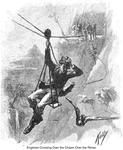
Engineers were often compelled to triangulate from the opposite
side to mark out the course of the road; while in one case, they
and their men were conveyed across a valley on wire ropes, suspended
some hundred feet in the air between two cliffs. From Tambo de
Viso to Rio Blanco, the present terminus of the rail, and only
fifteen miles distant, the road passes through twenty-two tunnels.
In some cases the work has been done by the diamond drill, the
rock often being so hard as to score glass. Tunnels Nos. 18 and
19 are separated by a short bridge that spans a chasm. Along this
portion of the route the dark line of the road may be traced,
now on the face of a cliff, now disappearing behind a projecting
mass or in a tunnel, but always ascending under the most adverse
circumstances. Between tunnels 19 and 22 formidable obstacles
opposed its construction. The road-bed, as usual, conforms closely
to the configuration of the ridges, crosses the Parac River,—here
a headlong torrent, emptying into the Rimac from the eastward,
and continues on to Tamboraque, along the Rimac. Then another
retrograde development becomes necessary, and the road being reversed,
returns along the bank of the Rimac to the valley of the Parac;
ascends that branch for half a mile to another switch, and returns
the second time to the Rimac, high above the lower line, passing
through two tunnels, one almost directly above the other. The
view from the spur which divides the two valleys is superb in
the extreme, and affords an extended panorama of Andean scenery,
seldom seen and rarely equaled. Presently we look down upon the
primitive little village of San Mateo, nestling in the valley
under the shelter of lofty mountains, and in general character
very much resembling Matucana.
For a short stretch of two miles beyond San Mateo, the mountains
approach each other so closely, and tunnels follow in such quick
succession, that light and darkness are very equally divided.
Between San Mateo and Anchi we cross a terrible gorge called "Los
Infiernillos,"* where the river passes through two walls
of red porphyry that rise perpendicularly to a height of from
1,000 to 1,500 feet. These form two reverse quadrants, and the
Rimacnow a mountain torrent-plunges, roaring, leaping, and foaming
into the abyss.
"This, as it frothed by, might have been a bath
For the fiend's glowing hoof."
* Little Hells.
456
 The bridge
that spans the chasm is 160 feet high, but masses of rock thrown
down during its construction have lessened its apparent height.
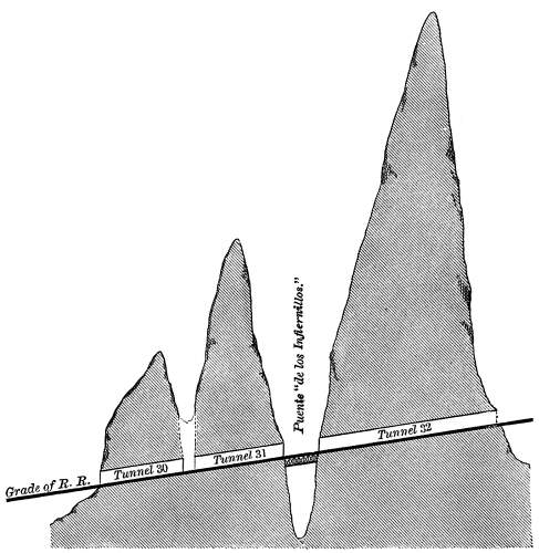
We emerge from a tunnel to cross the "puente de los Infiernillos,"
and we depart in like manner. Seen from the contracted valley
beneath, a train of cars must appear to spring mysteriously and
suddenly over the graceful little structure, and to disappear
like a thing of will and might, burrowing through the very heart
of the mountains. The diagram on page 455 will furnish a profile
of the country at this point, and give a faint idea of the marvelous
resources in engineering required to accomplish such tasks as
the nature of its formation imposes. The three tunnels, Nos. 30,
31 and 32, are so close together as to be almost one. After passing
through No. 32, the road continues to ascend by another zigzag,
rendered necessary by the very much increased grade of the valley
of the Rimac just below Anchi, where it is spanned by a bridge
107 feet above the stream. The bridge
that spans the chasm is 160 feet high, but masses of rock thrown
down during its construction have lessened its apparent height.
We emerge from a tunnel to cross the "puente de los Infiernillos,"
and we depart in like manner. Seen from the contracted valley
beneath, a train of cars must appear to spring mysteriously and
suddenly over the graceful little structure, and to disappear
like a thing of will and might, burrowing through the very heart
of the mountains. The diagram on page 455 will furnish a profile
of the country at this point, and give a faint idea of the marvelous
resources in engineering required to accomplish such tasks as
the nature of its formation imposes. The three tunnels, Nos. 30,
31 and 32, are so close together as to be almost one. After passing
through No. 32, the road continues to ascend by another zigzag,
rendered necessary by the very much increased grade of the valley
of the Rimac just below Anchi, where it is spanned by a bridge
107 feet above the stream.
Anchi is principally a railroad settlement, situated at the
junction of the Rimac and the Rio Blanco. It is 74 miles from
Lima, 11,300 feet above tide-water, and lies in the very gorge
of the mountains. Even from this elevated spot the snow-clad Andes
appear as high above us as they did some distance below, and we
find that there is still an ascent to be made of 4,000 feet. This
little collection of shanties is a mile below Rio Blanco, to and
from which point freight and passenger cars run daily with regularity
and dispatch. Here we begin to experience some of the disagreeable
physical effects of the rarified air of great altitudes, of which
the soroché is the most painful and dangerous. It is a
congestion of the lungs, and is accompanied by a sensation somewhat
resembling sea-sickness, besides pains in the back, the eyes and
ears, vertigo, and general debility. Persons of a full habit are
the greatest sufferers, but those who, like Cassius, are of "a
lean and hungry look," escape with less inconvenience.
The trip by rail is now at an end, the road not being in working
order beyond this point. We pass a night of refreshing sleep at
Anchi, under seven blankets, and are prepared to complete the
journey the next morning on horseback, in company with the resident
engineer, Mr. Tobias, Dr. Ward, the physician, and Lieutenant
Derby, U. S. N., our fellow-travelers from Lima. The distance
by rail to the summit is twenty-one miles, but it is greatly reduced
by avoiding the switches and pursuing the more direct mule-paths.
In this short distance are twenty-two tunnels. Much of the 'heaviest
work and the longest tunnels are so far advanced toward completion
as to require but a short time to put them in order for travel.
457
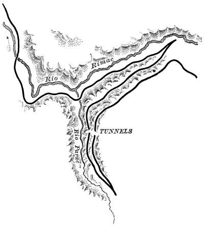
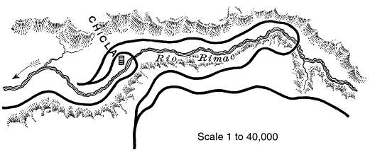
 At Anchi the
valley of the Rimac trends sharply to the northward, and the line
of the road follows the Rio Blanco for A mile and a half, then
makes a full detour, and returns to the left bank of the Rimac,
which it pursues, passing through seven tunnels to the village
of Chicla, where occurs the greatest development on the entire
route. No less than five almost parallel lines are visible from
any point of the valley,—three on one side and two on the
other of opposite mountains,—while the greatest distance
between any two of them is scarcely five hundred feet. This remarkable
zigzag will be understood by studying the diagram, wherein we
trace the road crossing the Rimac on a sharp detour, thence returning
to the right bank of the stream for a short distance to a switch,
where it is directed once more to, the northward for a while;
again crosses the Rimac on a short curve, retraces its course
along the left bank below Chicla to a second switch, which returns
it on its direct course on the same side, and above the other
line, to Casapalca, seven miles from Anchi, and a point at which
the roadbed attains an elevation of 13,615 feet above the sea.
Between Chicla and Casapalca we pass several half-ruined villages,
resembling those already described, with irregular rows of wretched
mud huts just as filthy, and inhabitants equally ignorant and
indifferent. They belong to the most enervated tribe of the South
American Indians, and subsist upon the little the rocky earth
yields to their indolent efforts. At Anchi the
valley of the Rimac trends sharply to the northward, and the line
of the road follows the Rio Blanco for A mile and a half, then
makes a full detour, and returns to the left bank of the Rimac,
which it pursues, passing through seven tunnels to the village
of Chicla, where occurs the greatest development on the entire
route. No less than five almost parallel lines are visible from
any point of the valley,—three on one side and two on the
other of opposite mountains,—while the greatest distance
between any two of them is scarcely five hundred feet. This remarkable
zigzag will be understood by studying the diagram, wherein we
trace the road crossing the Rimac on a sharp detour, thence returning
to the right bank of the stream for a short distance to a switch,
where it is directed once more to, the northward for a while;
again crosses the Rimac on a short curve, retraces its course
along the left bank below Chicla to a second switch, which returns
it on its direct course on the same side, and above the other
line, to Casapalca, seven miles from Anchi, and a point at which
the roadbed attains an elevation of 13,615 feet above the sea.
Between Chicla and Casapalca we pass several half-ruined villages,
resembling those already described, with irregular rows of wretched
mud huts just as filthy, and inhabitants equally ignorant and
indifferent. They belong to the most enervated tribe of the South
American Indians, and subsist upon the little the rocky earth
yields to their indolent efforts.
458
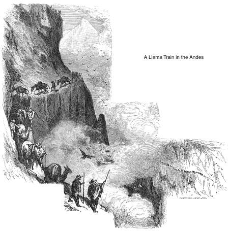
 Through this
section of the road, the solitude of the mountains is frequently
broken by droves of llamas, or South American camels, and long
trains of mules and donkeys laden with fruit and eggs. Flocks
of condors soar above them, awaiting a repast on some overburdened
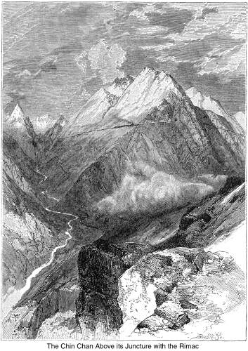
and disabled beast. A few miles above Casapalca, and nearly opposite
Anterangra, the narrow valley of the Chin Chan open's suddenly
from, the north, and divides two towering ridges crested with
perpetual snow. From this point a number of experimental lines
were run; but the one selected crosses the Rimac and advances
up the Chin Chan for two miles and a half, where, making a sharp
detour, it returns above the Through this
section of the road, the solitude of the mountains is frequently
broken by droves of llamas, or South American camels, and long
trains of mules and donkeys laden with fruit and eggs. Flocks
of condors soar above them, awaiting a repast on some overburdened
and disabled beast. A few miles above Casapalca, and nearly opposite
Anterangra, the narrow valley of the Chin Chan open's suddenly
from, the north, and divides two towering ridges crested with
perpetual snow. From this point a number of experimental lines
were run; but the one selected crosses the Rimac and advances
up the Chin Chan for two miles and a half, where, making a sharp
detour, it returns above the 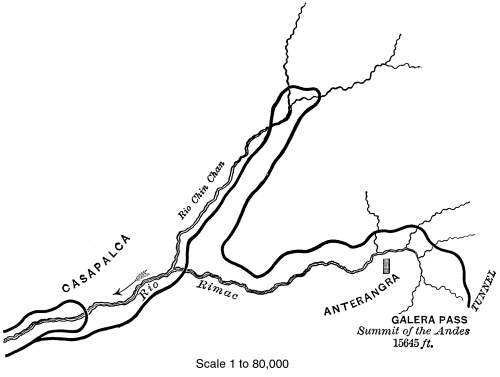 first line, and re-appears on the right bank of the
Rimac, 1,000 feet above the bed of the valley. This great elevation
affords a view of impressive grandeur. On one side conical snow-peaks,
glistening under the rays of a tropical sun, raise their impassive
fronts, and, wrapped in white mantles, show no traces of the agitations
that have marked the nearer ridges. These, as if they bad been
plastic masses, are molded along their base into a continuous
line of rude columns in half relief-some almost upright, some
aslant, while through their upper walls jagged and irregular masses
of dark igneous rock have been forced into violent prominence.
They rise like a succession of natural fortifications around the
valley, and so unscalable are they, and so securely does the valley
appear to be inclosed, that no other mode of egress seems possible
than that of the condor. But the fortress is undermined, and escape
is effected through seven tunnels, all in the space of a mile.
From this point to the dividing crest of the Andes, the line of
the road is often lost to sight amid desolate masses of snow and
ice. first line, and re-appears on the right bank of the
Rimac, 1,000 feet above the bed of the valley. This great elevation
affords a view of impressive grandeur. On one side conical snow-peaks,
glistening under the rays of a tropical sun, raise their impassive
fronts, and, wrapped in white mantles, show no traces of the agitations
that have marked the nearer ridges. These, as if they bad been
plastic masses, are molded along their base into a continuous
line of rude columns in half relief-some almost upright, some
aslant, while through their upper walls jagged and irregular masses
of dark igneous rock have been forced into violent prominence.
They rise like a succession of natural fortifications around the
valley, and so unscalable are they, and so securely does the valley
appear to be inclosed, that no other mode of egress seems possible
than that of the condor. But the fortress is undermined, and escape
is effected through seven tunnels, all in the space of a mile.
From this point to the dividing crest of the Andes, the line of
the road is often lost to sight amid desolate masses of snow and
ice.
Very heavy work had to be done and great obstacles overcome;
but, still it pushes on, rising higher and higher, winding around
the fountain-springs of the Rimac, its companion from the ocean,
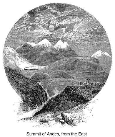
until it finally reaches the dreary summit of the Andes, and enters
459
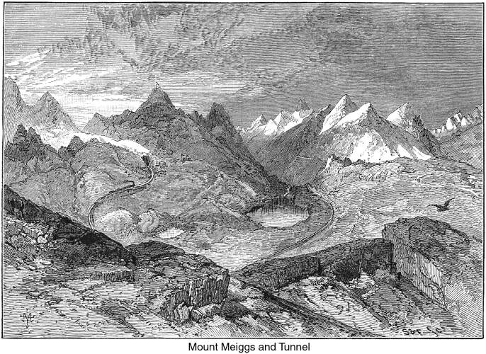
the Galera, or "tuñel de la Curia," as it
is styled by the Peruvians. This tunnel is 1,173 meters, or 3,847
feet in length, and enters the mountain about 680 feet beneath
the apex of an undulation lying between Mount Meiggs on the right
and two gigantic peaks on the left. It is ninety-seven miles from
Lima, and has an altitude above the sea of 15,645 feet, being
only 136 feet below the very top of Mont Blanc.* Although not
completed, it is open throughout its entire length, and could
soon be put in condition for travel. Its construction was attended
with unparalleled difficulties, demanding unceasing effort and
the greatest powers of human endurance. All the machinery for
boring and working the approaches came from the workshops of Lima,
and were brought on the backs of mules from the terminus of the
rail. In the progress of the tunnel every step was impeded by
snow-water percolating from above, often bursting through seams
and driving the peons from their work. And, although the most
hardy serranos were employed, and those inured to the painful
effects of a very rarified atmosphere, yet even they were frequently
disheartened by their many trials. Thus, this tunnel of the summit
is the monument of a heroic determination which has wrought victoriously,
through eternal winter and desolation, to gain a trans-Andean
world laden with the ungathered fruits of perpetual summer.
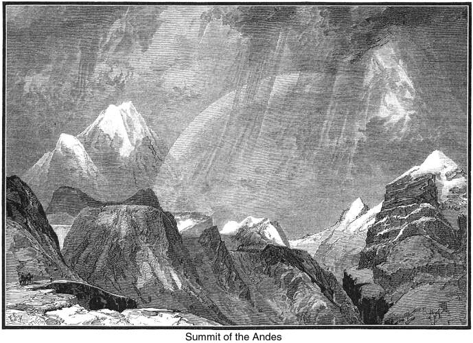
Mount Meiggs, named in honor of the distinguished contractor,
Mr. Henry Meiggs, is a short distance south of the tunnel. It
is 17,500 feet above the sea, and from its conical peak float
the American and Peruvian flags. A small observatory, in which
the barometer indicates the pressure of the atmosphere to be 17
inches, and the thermometer stands at the freezing point, permits
the traveler to contemplate the surrounding scene at his leisure.
Towering snow-peaks encircle an icy plateau, with no opening between
them, except where the Rimac has forced its way. A sky of the
deepest blue throws into bold relief these "giants of frost
and snow," fit sentinels between land and sky, and as yet
undisputed possessors of their dreary abode. We say as yet undisputed,
for in view of the journey we have just accomplished, it would
be folly to feel secure of any uninvaded territory. The trip has
seemed a dream of wonder and enchantment; and having arrived safely
at its end,
* Mont Blanc is 15,781 feet above the sea,
according to Coraboeuf.
460
we already begin to sigh for new powers of locomotion,—unattained
aerial heights, fresh prodigies of skill! But obviously, such
travels must be delayed for a time, and we return to our still
extraordinary bit of terra firma to sketch the remainder of the
route, and some circumstances and results connected with the great
Andean highway.
 From the eastern
outlet of the Galera, the line descends to Oroya at a moderate
grade, and without encountering any formidable difficulties. Throughout
the latter portion of the road, including the section between
Rio Blanco and the summit, a distance of 53 miles, a considerable
amount of grading has been done, while much of the track is in
such an advanced state as to require but little additional labor
to put it in condition for travel. At present, the work is suspended
in consequence of the depressed condition of the Peruvian finances.
Oroya is situated at the junction of the Yauli and Jauja rivers.
It is 12,178 feet above the sea, and 129 miles from Lima; and
here the contract for the road terminates. From this place to
the nearest navigable point on the Amazon is 250 miles. When the
connecting road shall be completed, it is estimated that the traveler
landing at Calláo can reach a steamer on the Amazon in
from 20 to 30 hours; thence to Para is about 2,000 miles. A week,
or even less perhaps, of travel down the mighty river, through
its magnificent forests, and the Atlantic is under his keel! From
Oroya may be run two branch lines,—one northward, for which
Mr. Meiggs is already in treaty with the government, namely, to
the Cerro de Pasco, the richest silver mines in the world; and
the other running south to Jauja, whose delightful climate would
make it a favorite resort for invalids. From the eastern
outlet of the Galera, the line descends to Oroya at a moderate
grade, and without encountering any formidable difficulties. Throughout
the latter portion of the road, including the section between
Rio Blanco and the summit, a distance of 53 miles, a considerable
amount of grading has been done, while much of the track is in
such an advanced state as to require but little additional labor
to put it in condition for travel. At present, the work is suspended
in consequence of the depressed condition of the Peruvian finances.
Oroya is situated at the junction of the Yauli and Jauja rivers.
It is 12,178 feet above the sea, and 129 miles from Lima; and
here the contract for the road terminates. From this place to
the nearest navigable point on the Amazon is 250 miles. When the
connecting road shall be completed, it is estimated that the traveler
landing at Calláo can reach a steamer on the Amazon in
from 20 to 30 hours; thence to Para is about 2,000 miles. A week,
or even less perhaps, of travel down the mighty river, through
its magnificent forests, and the Atlantic is under his keel! From
Oroya may be run two branch lines,—one northward, for which
Mr. Meiggs is already in treaty with the government, namely, to
the Cerro de Pasco, the richest silver mines in the world; and
the other running south to Jauja, whose delightful climate would
make it a favorite resort for invalids.
Thus much for the picturesque and descriptive part of our task.
We proceed now to give a slight history of the great enterprise.
Don Manuel Pardo, previous to his being President of Peru, was
obliged to seek some climate that might restore his health, and
he found it in the province of Jauja. "In this rich part
of Peru," says Mr. Hutchinson,* "his stay was turned
to good account by a pamphlet† which he published, containing
his observations on its wealth of minerals, and on the railways
that by this route might cross the Andes, as well as open up the
interior resources of the republic. In this brochure he discusses
the subject of peopling the valleys of the Amazon, and argues
against the error of supposing that this ought to be done, as
far as Peru is concerned, by medium of that part of the mighty
river which flows through much of Brazil." * * * "The
further purpose of the pamphlet is to advocate a railway from
Lima to Jauja, which is considered the most salubrious province
in Peru, and where magic cures of the aggravated forms of phthisis
pulmonalis (consumption) have been effected. It may be seen by
the map," continues Mr. Hutchinson, "that the Oroya
line now in progress is the first step toward accomplishing this
great work, originally suggested by Don Manuel Pardo." But
to General Pedro Diez Conseco has usually been accorded the credit
of having conceived the great project. The honor however, of practically
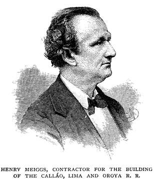
working out the plan, by whomsoever proposed, is due to our countryman,
Mr. Henry Meiggs, whose perseverance, indomitable energy, and
great executive ability, have been fully equal to the task he
has undertaken. He has been assisted by an able corps of engineers,
among whom, Mr. L. Malinowski, the chief engineer, had much to
do with the selection of the route. Mr. Meiggs contracted to build
and equip the entire road for the sum of 27,600,000 soles, or
about $200,000 a mile, and be stipulated to have the line in good
running order in six years from the date of signing the contract,
provided the government should meet its obligations.
* Two Years in Peru, with Exploration of
its Antiquities, by Thomas J. Hutchinson, F.R.G.S., F. R. S.
L., M. A. I. London: Sampson, Son, Marston, Ives & Searle.
1873.
† "Estudios sobre la Provincia de Jauja,"
por Don Manuel Pardo. Lima: Imprenta. de la "Epoca,"
por Jose E. del Campo, Calle de la Rifa, Num. 58, 1862.
461
The great cost of this undertaking, and of other enterprises
of equal magnitude in which the government has been engaged, has
seriously embarrassed it in a time of such general financial depression
as the present, so that Mr. Meiggs's far reaching plans have not
been fully accomplished.
The sum allowed Mr. Meiggs for building the Oroya Railroad
may seem very large in comparison with our own roads, which average
only about $60,000 a mile; but it does not very greatly exceed
the total cost per mile of the railroads of Great Britain, which
amounts to about $170,000. The contract included everything connected
with the survey, construction, and right of way, besides the furnishing
of all supplies, the building of necessary docks at Calláo;
of station, freight, and engine houses, and the supplying of a
certain number of engines, coal, freight, and passenger cars-in
fact, the whole equipment of a first-class railway. The rolling
stock has been imported from the eastern workshops of the United
States, the rails from England, and the cross-ties from California.
All the plant for the construction of the road had to be transported
by mules, and the cost of new mule-paths to replace those occupied
by the rails, as they advanced, is estimated to have been $500,000.
Atone time, there were 850 mules and 150 horses in the employ
of the company, and the transportation cost was 3,000 soles a
day. The roadbed has been made in the most secure manner, and
its superstructures are of the best materials. The striking characteristic
here, as with everything else done by Mr., Meiggs in Peru, is
the perfect adaptation of the work to its end. Besides innumerable
bridges, there are 61 tunnels, aggregating 20,000 feet in length,
and a majority of them are built upon curves of a minimum radius.
The powder alone for blasting purposes amounted to 53,250 quintals,
or over 5,000,000 lbs., and cost about 750,000 soles. One part
of an embankment near the Verrugas bridge contains 90,000 cubic
yards of material. The natives, as a class, were not friendly
to the road, and the right of way had often to be purchased at
a cost very much beyond the value of the land.
Notwithstanding the great care and attention paid by Mr. Meiggs
to the well-being of his workmen, who have been principally Chilians
and Chinese, at least 10,000 persons are computed to have died
thus far in the progress of the work. An intermittent fever of
a very malignant character broke out in 1870 and 1871 among the
Chilians employed
462
between the Cupiche bridge and Coracona, and scarcely one in
a hundred recovered. A disease peculiar to the valley of the Rimac,
although less fatal than the so-called Oroya fever, has occasioned
great suffering and inconvenience. A bloody wart or excrescence
comes out upon the skin, and while it lasts, and even before it
appears, the system is greatly depressed, for the warts often
bleed profusely, and men have been known to come in from their
work with their boots filled with blood. It has been supposed
to be caused by the water of that region. The soroché has
also very much hindered the progress of the work, and especially
of that part lying along the higher elevations.
 Mr. Meiggs
has a lease of the road at 6,000 soles per month, and he pays
all expenses and keeps the rolling stock in good repair. It is
directly under the supervision of Mr. Cilley, who, as superintendent,
conducts it in a very efficient manner. Mr. H. J. Kingman is the
road-master, Mr. H. P. Tobias, the resident engineer, and Dr.
George A. Ward, the attending physician, attached to the road.
These gentlemen are all Americans, and conduct their several departments
with great skill and judgment. Mr. Meiggs
has a lease of the road at 6,000 soles per month, and he pays
all expenses and keeps the rolling stock in good repair. It is
directly under the supervision of Mr. Cilley, who, as superintendent,
conducts it in a very efficient manner. Mr. H. J. Kingman is the
road-master, Mr. H. P. Tobias, the resident engineer, and Dr.
George A. Ward, the attending physician, attached to the road.
These gentlemen are all Americans, and conduct their several departments
with great skill and judgment.
We have been accustomed to consider the railway over the Alps
and the tunneling of Mont Cenis as a very great achievement. But
that ascent was made by only six zigzags, and at the culminating
point the tunnel is but 4,236 feet above the sea.
Therefore, the Oroya Railroad must take rank in the history
of modern engineering as a work of the first magnitude, without
a rival. It has been urged that this distinction has not been
attained without entailing a very serious burden of debt upon
the Peruvian government if the road should not be a commercial
success. Even if this should be the case, and the road should
continue no farther than Cerro de Pasco, that branch line must
ultimately connect with the valley of the Chanchamayo, a region
of extraordinary fertility, by a road which must be remunerative.
Thence to the Amazon by the valley of the Ucayali, would not be
very far. When Mr. Meiggs made the contract for the first Peruvian
railway, in 1868,—that between Mollendo and Arequipa,—Peru
was very far behind other nations, and especially her sister republic
of Chili, in the matter of internal improvements. There was no
community of interests between the various divisions of her territory.
The whole country was stagnating for the want of development,—and
that where every climate might be enjoyed, from tropical warmth
to Arctic cold; where the earth yields, in abundance, cotton,
rice, tobacco, corn, and every known variety of fruit and vegetable,
and many medicinal plants; and where unknown wealth is stored
up in mines of gold, silver, copper, iron, lead, and coal, besides
cobalt, nickel, platinum, quicksilver, saltpeter, and mercury.
Peru possesses a rich heritage in the basin
463
of the Amazon; for there Nature works on her largest and most
prodigal scale;* there she annually wastes as much, it is said,
as would feed the whole population of China;
The Amazon," says a recent writer: † "drains
a million more square miles than the Mississippi," and within
its capacious valley "the whole of the United States could
be packed without touching its boundaries." To leave her
share of this magnificent domain undeveloped would be fatal to
the best interests of Peru, and, indeed, a loss to the world;
for when the native tribes of the Montaña shall disappear,
as they must, before the advance of civilization, and shall be
replaced by industrious and skilled laborers from Europe, Asia,
and the United States, it is impossible to estimate how great
will be the gain to commerce from the opening and cultivation
of this bountiful land. The time is yet far distant, it may be,
before this end can be attained; but steam alone can hasten the
day, and bring unity to a nation as divided by natural barriers
as Peru. As to the ultimate result of the great highway across
the continent of South America, Mr. Bates, an enthusiastic British
naturalist, who lived for seven years on the banks of the upper
Amazon, has, in advance of the enterprise, suggested a future
of magnificent possibilities: "Although humanity," he
says, "can reach an advanced state of culture, only by battling
with the inclemencies of nature in high latitudes, it is only
under the equator that the perfect race will attain to complete
fruition of man's heritage,—the earth." ‡
In the meantime, as we do not yet possess that complete balance
of the mental and physical powers which would warrant us in seeking
a residence in this equatorial paradise; and as one cannot always
"* * poise about in cloudy thunder-tents,
To watch the abysm-birth of elements,"
we retrace our way to latitudes in which the vicissitudes are
such as to insure the attainment of a perfect culture. And what
a retracing of the way! A mere railway carriage is but a rude
mode of descending from the clouds. Might we gratify the aspirations
raised by the upward journey, we would fain make for the downward
trip
"* * a ladder of the eternal wind;"
or we would bestride a captured thunderbolt. But, alas! these
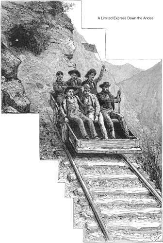
elemental conveyances must give way to the more practicable, though
perilous, hand-car. Thus it is, that in a material age, every
adventurous American returns over the Oroya Railroad, down the
declivities of the rugged and formidable Cordillera.
At Anchi, 12,000 feet above the Pacific, the hand-car is loaded
with its freight of six adventurous sightseers, closely braced
together. It is of the ordinary construction and appearance, and
does not offer any temptations to a pleasure excursion down the
precipitous and tortuous gorge of the Rimac, except that it affords
an unobstructed view of the shifting grandeur and terrors of the
route. As we descend in our rough vehicle, at the rate of 60 miles
an hour; flying across aerial viaducts, or dashing through sepulchral
tunnels; threatened, now, to be crush "between converging
mountain walls, or precipitated from pendulous terraces,—the
foaming Rimac emulating the maddening speed; now glancing back
to take a last look at the glistening pinnacles of the receding
Andes; or, straining eagerly forward, to catch the first glimpse
of the royal city of the plain and the shining ocean,—the
magnificence of the scenery and the magnitude of Mr. Meiggs's
achievement break upon us with fresh force, and not for any peril
of the way would we forego the exhilaration and novelty of the
trip. Far otherwise was it with one of the party,—a stately
commodore. He, who could face unflinchingly a whole broadside
of murderous missiles, sprang from the car after ten miles over
the wildest part of the route, declaring that nothing would tempt
him to repeat such a foolhardy experiment. For the rest of us,
the excitement and exhilaration of this mode of travel became
so attractive, that we often went up to Anchi for the sole purpose
of making the down trip.
It will be seen that a railway over the Andes is virtually
an accomplished fact. There must be a force inherent in this portion
of the American continent which compels to Herculean labors. The
Cordilleras themselves were not produced from the bosom of the
ocean but by mighty throes; and where the lofty Illampu crowns
the chain, the powerful empire of the Incas arose, amid and wastes
and frigid desolation. More than twelve thousand feet above the
sea, two bleak islands of Lake Titicaca are covered with dilapidated
temples and palaces, and terraces whose flowers once bloomed
* Taken from a letter without signature,
in Herndon's "Explorations of the Sources of the Amazon."
† The Andes and the Amazon; or, Across the Continent of South
America. By James Orton, M.A.
‡ The Naturalist on the Amazons. By Henry Walter Bates. London:
John Murray.
464
 on a soil that
had been brought, it is said, four hundred miles; and a fountain
still flows with water conducted from unknown sources. A thousand
feet below is Cuzco, the once famous city of the sun; and to this
day, it reflects in its cyclopean walls the ambitions and polity
of its Incarial rulers, who had pleasure-grounds and palaces in
the valley of Yucay, encircled by mountains still terraced to
the summit of vanishing heights, and still fortressed on dizzy
crags and forbidding passes. In the midst of the Thibet of the
new world, Tiahuanuco was the center of an empire even more remote,
and its ruins represent a civilization possibly contemporaneous
with that of Egypt.* Even in its ruins, it excites the wonder
and admiration of the traveler, who compares them not unfavorably
to Stonehenge and Avebury. Remains as vast and impressive are
to be seen on the dreary dunes of the coast. Is it strange, then,
that men of the present, surrounded by such colossal formations,
natural and artificial, should come under the sway of the same
irresistible power; and that they should vie with the past in
the stupendous character of their undertakings? on a soil that
had been brought, it is said, four hundred miles; and a fountain
still flows with water conducted from unknown sources. A thousand
feet below is Cuzco, the once famous city of the sun; and to this
day, it reflects in its cyclopean walls the ambitions and polity
of its Incarial rulers, who had pleasure-grounds and palaces in
the valley of Yucay, encircled by mountains still terraced to
the summit of vanishing heights, and still fortressed on dizzy
crags and forbidding passes. In the midst of the Thibet of the
new world, Tiahuanuco was the center of an empire even more remote,
and its ruins represent a civilization possibly contemporaneous
with that of Egypt.* Even in its ruins, it excites the wonder
and admiration of the traveler, who compares them not unfavorably
to Stonehenge and Avebury. Remains as vast and impressive are
to be seen on the dreary dunes of the coast. Is it strange, then,
that men of the present, surrounded by such colossal formations,
natural and artificial, should come under the sway of the same
irresistible power; and that they should vie with the past in
the stupendous character of their undertakings?
* Peru. Incidents of Travel and Exploration
in the Land of the Incas. By E. George Squier, M.A., F.S.A. Harper
& Brothers, New York.
Mountain
Railroading | Contents Page
|