THE INTEROCEANIC SHIP RAILWAY
Scientific American—December 27, 1884
A STEAMER IN TRANSIT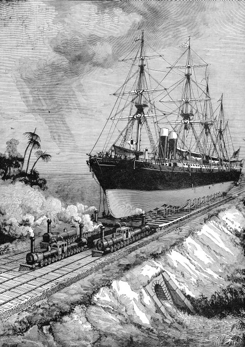
The transisthmian projects which for many years have attracted
the attention of engineers may be divided, perhaps not improperly,
into three classes: 1st. Those in which the construction will
be at the mercy of floods. 2d. Those lacking good harbors. 3d.
Those which empty into the Doldrums or Zone of Calms. Of these
three fatal objections, the Panama tide water canal scheme is
open to the first and third, and the Nicaragua lifting-lock plan
to the second and third. The ship railway project of Mr. James
B. Eads, illustrated in this number, is open neither to the one
objection nor to the other, and besides being far less costly,
it furnishes a quicker means of isthmian transit than either of
them, and will shorten by considerably over a thousand miles the
contemplated route via Panama between our Atlantic States
and San Francisco or the East Indies.
Until the arrival in the field of Mr. Eads, it seemed to have
occurred to no one that anything but a waterway would serve for
ship transit between the two oceans. It did not appear impracticable
to some of the transisthmian projectors to build a ship canal
in a region annually inundated by mountain streams, or to expect
sailing vessels to traverse hundreds of miles of wind-bereft seas.
But to take ships across a narrow isthmus by rail was monstrous,
and not to be thought of.
It is no part of the purpose of this article to cast discredit
upon the rival projects of Panama and Nicaragua, but the promoters
of both the one and the other, in very laudable efforts in support
of their own theories, have led at least a portion of the unthinking
public to look upon the ship railway scheme as impracticable and
visionary, and a comparison is necessary to show the relative
practicability of the ship railway and the two most prominent
canal schemes, and its superior advantages when considered from
a commercial standpoint. In making this comparison, however, we
shall endeavor to give each its just due, setting down naught
in malice.
A careful study of the engravings as presented in this number,
and the explanation which accompanies each, will show that while
the ship railway is novel and original when taken as a whole,
it demands no other methods in the treatment of a ship than those
usually employed in the dry dock and the marine railway, and which
experience has shown to be safe. Indeed, the only remarkable thing
about the scheme is that no one has ever thought of it before.
In the ship railway project a ship is lifted out of the water
by means of a submerged pontoon, similar to those in use all over
the world; but no such force as that used in hauling a ship up
out of the water on a marine railway is required on the ship railway,
although, as well known, ships are constantly taken on the marine
railway without injury. In the Eads system, however, there is
no necessity for using any force whatever on the ship itself.
It is lifted out of the water in a cradle which rests upon
a series of rails; and these being brought even with the tracks
on the dry land, the cradle in its capacity of a car is wheeled
along an almost level railway across the Isthmus of Tehuantepec,
and when it reaches the other side a similar means is employed
to float it again. This is the whole project—a combination
of the lifting dock in general use and an improvement upon the
marine railway, because the ship is never, as in the latter, required
to be off an even keel.
Looking upon the chart, we find that the Isthmus of Tehuantepec
is in Mexico, and in the extreme northern end of the long, slim
neck of land which separates North from South America, and that
the Isthmus of Panama is on the extreme south end of Central America,
and at the farther end of this strip of land. Having discovered
this, we naturally turn to a consideration of ocean lanes from
the Atlantic and Gulf States to California and the East Indies,
and from California to the British Islands, because, in these
days of expedition, the shortest route, all else being equal,
is sure to prove the most popular. We have not proceeded far in
this inquiry when the advantages of the Tehuantepec route in time
and distance become plainly apparent.
From New York to San Francisco via the Panama Canal,
a steamship would be compelled to pass the Isthmus of Tehuantepec,
sail south about 1,200 miles, and after crossing sail north again
the same distance before reaching the short route to San Francisco.
In other words, she would have to traverse about 1,200 miles more
than if she had crossed the isthmus at Tehuantepec. From Gulf
ports to San Francisco and the East the difference in distance
in favor of Tehuantepec is still more marked; the route between
New Orleans and San Francisco via Tehuantepec being about
nineteen hundred (1,900) miles shorter than vice Panama. From
Liverpool to San Francisco there is a saving of 600 miles via
Tehuantepec. With sailing vessels—and sailing vessels, much
as we hear of steamers, carry fully three-quarters of the world’s
freights to-day, and are likely to continue to carry slow freights—the
contrast is still more marked.
A sailing vessel having crossed the Isthmus via Panama
is left in a very ocean of waters, over which reigns a perennial
calm, broken only by occasional squalls and baffling zephyrs.
She must be towed hundreds of miles until the region of the trade
winds is reached. This, of course, serves to add a large expense
to the voyage and to lengthen it many days, so that when we say
the voyage between the Atlantic States and California is shorter
by 1,200 miles via Tehuantepec than it is via Panama,
we greatly underestimate the advantages of the former route. It
would be a generous estimate to allow for only ten days’—good
authorities say from 20 to 30 days’—delay between the
Pacific side of the Panama Canal and the point where a sailing
ship strikes the northeast trades, by reason of calms and the
slow progress made while in tow. Allowing that a sailing ship
can average 170 statute miles in a day’s run, this would
add 1,700 miles to the 1,200 miles extra run required via
Panama, and hence would serve, practically, to make the Tehuantepec
route 2,900 miles shorter in the run from New York to San Francisco,
and 3,500 miles shorter in the run from New Orleans to San Francisco.
In confirmation of this, indeed, as showing that in the above
we have underestimated the time required by sailing vessels via
Panama to cross the calm zone, we append herewith the testimony
of a practical seaman, Captain Silas Bent, as given before the
Merchants’ Exchange in St,. Louis, pending the unanimous
adoption by that body of the resolution recommending a favorable
consideration of the ship railway to the United States Government:
"Mere statements of the difference in miles is a very inadequate
measure," he says, "of the difference in time that would
be occupied by sailing vessels in making these several passages;
and when we consider that three-fourths of the ocean commerce
of the world is carried in sailing vessels, you can see what an
important factor this question of sailing time, becomes in the
solution of the problem before us.
"The northeast trade winds which extend across the Atlantic
are so broken and interrupted when they encounter the West India
Islands that they never penetrate the Caribbean Sea; but the northwest
portion of them, however, do extend into the Gulf of Mexico, and
often so far down as to reach well toward Tehauntepec, so that
while in the Gulf winds are always found, yet the Caribbean Sea
remains a region of almost relentless calm.
"Nor is this all, for the mountain ranges, extending the
length of the Isthmus of Panama and through Central America, offer
a still more formidable barrier to the passage of these winds,
thus throwing them still higher into the upper regions of the
atmosphere, and extending these calms far out into the Pacific
Ocean, on the parallel of Panama, with lessening width, for fifteen
or eighteen hundred miles to the northwest, along the coast of
Central America.
"This whole region of calms, both in the Caribbean Sea
and in the Pacific Ocean, is so well known to navigators that
sailing vessels always shun it, if possible, though they may have
to run a thousand miles out of their way to do so.
"This absence of wind, of course, leaves this vast area
exposed to the unmitigated heat of a torrid sun, except when relieved
momentarily by harassing squalls in the dry season and by the
deluging rainfalls of the wet season. With these meteorological
facts in view, let us now suppose that the Lesseps canal at Panama
and the Eads railway at Tehuantepec are both completed and in
running order; then let us start two sailing ships, of equal tonnage
and equal speed, from the mouth of the Mississippi, with cargo
for China, one to go by the way of the Panama Canal, and the other
by the way of the Tehuantepec Railway, and I venture to affirm
that by the time the Panama vessel has cleared the canal and floats
in the waters of the Pacific, the Tehauntepec vessel will have
scaled the Isthmus and be well on to the meridian of the Sandwich
Islands; and that before the former vessel can worry through the
fifteen or more hundred miles of windless ocean before her, to
reach the trade winds to the westward of Tehuantepec, the latter
will have sped five thousand miles on her way across the Pacific,
and be fully thirty days ahead of her adversary. For it is a fact
worth mentioning here, that the strength of the northeast trade
winds in the Pacific, as well as the maximum strength of the northern
portion of the great equatorial current in that ocean, are both
found on or near the parallel of latitude of Tehuantepec, the
former blowing with an impelling force to the westward of ten
or twelve miles an hour, and the latter with a following strength
of three or four miles per hour."
It is not to be supposed that Mr. Eads hit upon the plan of
his railway before carefully studying the various canal projects;
such was not the case. It was in fact, the result of these canal
studies which led him to seek some other means of crossing the
narrow strip of land that separates North from South America.
For to his practical mind neither the one canal project nor the
other of them gave evidence of feasibility, owing to their excessive
cost. It was a great problem to solve! Here were a paltry forty
or one hundred miles of earth and rock, which, if pierced, would
serve to shorten by ten thousand miles the present voyage via
Cape Horn from New York to San Francisco, which now is 15,687
miles, and to reduce the distance by water between New Orleans
and San Francisco from 16,112 miles to something less than 4,000
miles.
It is not surprising that the mind that conceived the jetty
system, as applied to the mouth of the Mississippi River, should
not be thwarted by the obstacles which confront the transisthmian
projector; nor is it surprising to find that the plan that he
has hit upon is thoroughly original, or that it is decried by
those who do not understand it. Indeed, it would be more surprising
if this were not the case; for have not all original schemes been
laughed at? The idea, when first proposed, of forcing carbureted
hydrogen illuminating gas through the London streets furnished
no little amusement to the illuminati; when the project of sending
a vessel across the ocean to England propelled by steam was first
made public, an eminent scientist was so sure of the impracticability
of the scheme that he promised to swallow the vessel on its arrival;
when Captain Ericsson proposed to substitute for the direct action
of the paddle wheel the oblique action of the screw, he was looked
upon as bereft of reason. Yet all succeeded.
"Whatever is attempted without previous certainty of success,"
says an eminent writer, "may be considered as a project,
and among narrow minds may, therefore, expose its author to censure
and contempt; and if the liberty of laughing be once indulged,
every man will laugh at what he does not understand, every project
will be considered as madness, and every great and original design
will be regarded as impracticable. Men unaccustomed to reason
and researches think every enterprise impracticable which is extended
beyond common effects, or comprises many intermediate operations.
Many who presume to laugh at projectors or designers would consider
the navigation of the air in a flying machine as the dreams of
mechanic lunacy, and would hear with equal negligence of the accomplishment
of the Northwest Passage and the scheme of Albuquerque, the Viceroy
of the Indies, who, in the rage of hostility, had contrived to
make Egypt a barren desert by turning the Nile into the Red Sea."
Mr. Eads knew that ships had been going on and off lifting
docks without injury from time immemorial, and that vessels that
could safely withstand the terrible buffeting of ocean waves could
be moved over a smooth roadbed without fear of injury. In order
to be sure as to the roadbed, he took with him, to the Isthmus,
Mr. E. L. Corthell, an experienced and able engineer, who had
successfully carried out his plans at the mouths of the Mississippi,
and is an expert in railroad construction, having been chief engineer
of the West Shore Railroad. Being a practical man Eads, naturally
sought to discover a route that would furnish a substantial roadbed,
possess something in the shape of harbors at either end and above
all a location outside of that, to the mariner, vexatious belt
of perpetual calm. He found a cross section of the Isthmus of
Tehuantepec which combined all these qualities; nay, more, for
of all the routes across the narrow strip of land joining Mexico
with South America, none shortens so much as this the voyage from
the Atlantic and Gulf States to California.
Having selected the site for his ship railway, he now sought
a concession from the Mexican. Government. This was obtained in
1881, and extends over a period of ninety-nine years from its
date. It authorizes the construction across the Isthmus of Tehuantepec
of a ship railway, an ordinary railway, and a line of telegraph.
Besides this it exempts all ships and merchandise in transitu
from government duty, grants the concessionaire a million acres
of public land, and guarantees protection during the construction
and subsequent operation of the works. To crown all, the right
is given the company to obtain the aid of any foreign government,
and in consideration of this assistance the company is authorized
by the terms of the concession to discriminate in favor of the
commerce of such government against that of all other countries,
save, of course, Mexico. The concession obtained, Mr. Eads set
about having a careful survey made, topographical and physical,
for the several previous surveys were with reference to a canal
or an ordinary railway. One of the Eads surveys was made by Mr.
Corthell, and another by a party of engineers under the direction
of Don Francisco de Garay, an able Mexican engineer, with forty
assistants and linemen; he being assigned by the Mexican government
to assist Mr. Eads in making the survey. Two lines were run over
the mountains, and a careful hydrographic survey was made of the
approaches of the termini. A series of additional surveys were
recently made from Minatitlan to Bocca Barra and to Salina Cruz.
The length of the whole line will be about 134 miles from Atlantic
to Pacific. Beginning on the Atlantic side, the route will start
from the Gulf of Mexico, the ships sailing up the Coatzacoalcos
River to Minatitlan, a distance of about 25 miles. From Minatitlan
there extends for about 35 miles an alluvial plain having
an underlying stratum of heavy, tenacious clay. In the elevation
and ridges clay loam and sand are found. Next comes an undulating
table land, and then irregular mountain spurs of the main Cordilleras,
that run through the entire continent, making at this point one
of the most marked depressions to be found in its whole length.
From this basin the line passes through a valley formed by a small
stream to the plains of Tarifa, where is situated the summit of
the line. This is 736 feet above low tide. After traversing these
plains, the Pass of Tarifa is reached. This is the most accessible
of the many passes in this depression in the mountain chain. From
here the line gradually sinks to the Pacific, reaching the plains
on this side 118 miles distant from Minatitlan.
The pontoon, or floating dock (see Figs.1 to 4),
is of the same general construction as those in use all over the
world, save in some important modifications rendered necessary
to fit it for its special work. For it is not enough that the
vessel should be docked and lifted out of the water, but that
it shall be caused to rest upon a. cradle in such a manner that
its weight shall be equalized fore and aft, and thus enable the
carriage with its load to move easily and safely. This is effected
by means of a system of hydraulic rams arranged along an intermediate
deck about six feet below the upper deck of the pontoon (see Fig.
2). The arrangement of the rams is in both lateral and longitudinal
lines, the former standing a little less than seven feet apart,
the one from the other. The area of the combined rams in each
lateral line is the same; the area of the one ram under the keel
forward or aft is equal to the area of the five or seven rams
amidships. They may be connected and made to work in unison, so
that the same pressure per square inch of surface of the rams
will exist throughout the whole system, or they may be disconnected
by valves, so that a greater pressure may be brought upon the
rams in a certain section or on a certain line.
It is no part of the duty of these rams to lift the vessel.
They are designed only to resist its weight as it gradually emerges
from the basin. They get their power from a powerful hydraulic
pump placed on a tower affixed to the side of the pontoon, and
rising and sinking with it, but of such a height that, even when
the pontoon rests upon the bottom of the dock, it is not entirely
submerged. The pontoon itself is directed by powerful guides,
which cause it to descend and emerge from the water always in
the same position.
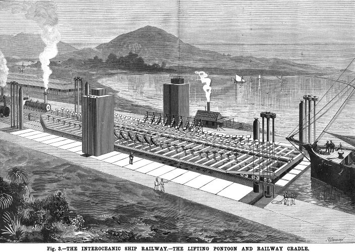
A ship having entered the mouth of the Coatzacoalcos River,
on the Atlantic side, and come up to the basin, the carriage with
its cradle is run on to the floating dock, then water is let into
the compartments of the pontoon, and dock and cradle gradually
sink to the bottom. Then the ship is brought in from the exterior
basin, and so adjusted as to position that her keel will be immediately
over the continuous keel block of the cradle, and her renter of
gravity over the center of the carriage. The water is then pumped
out of the submerged pontoon in the manner employed in floating
dock systems, and it rises gradually, bringing the cradle up cinder
the ship’s hull (see Fig. 2). As soon as the keel
block of the cradle is close to the ship’s keel, the hydraulic
pump is called into action, and pushes up the pendent rods and
posts of the supports gently against the vessel, closely following
the lines of her hull and the run of the bilge. The pressure upon
the rams increases as the vessel emerges from the water, but the
water pressure under them being prevented from escaping by the
closing of the valves, the ship’s weight, when she stands
clear of the water, is borne by the rams by means of the supports.
In the case of a ship weighing five thousand tons, each of
the fifty lines of rams would, of course, be called to sustain
a burden of exactly one hundred tons; and these lines being placed
at equal distances the one from the other, it will readily be
seen that each unit of the ship’s weight is equally distributed.
The weight and displacement of the vessel is learned from the
pressure gauge on the hydraulic pump.
The vessel being clear of the water, hand wheels or adjusting
nuts that move in threads cut in the columns of the supports are
run down to the bearings in the girder plates, whereupon the valve
is opened and the rams withdrawn, leaving the girders to support
the weight of the ship. Now each girder has the same number of
wheels, and as described above bears its just proportion of weight
and no more, hence each of the multitude of wheels under the carriage
is called upon to bear the same weight. This weight has been calculated
to be only from eight to nine tons, though tested to twenty.
One of the many ingenious contrivances in the scheme is the
"hydraulic governor," so called, and by which the unevenness
of the plane of the pontoon when it comes to the surface with
its load can be readily corrected. This apparatus is thus described:
"Two cylinders are attached to each corner of the dock,
one being upright and the other inverted. Plungers attached to
the pontoons move in them. These two cylinders are connected by
pipes, and all spaces in the cylinders and pipes are filled solid
with water. As the pontoon rises, the water forced out of one
cylinder by the ascending plunger is forced into the inverted
cylinder on the diagonal corner where the plunger is being withdrawn.
Now, if there is say one hundred tons preponderance on one end
of the pontoon, one-half this weight, or fifty tons pressure,
will be exerted by each plunger on that end upon the water in
its cylinder. This pressure is instantaneously transmitted through
the pipes to the water in the top of the upright cylinder in the
opposite diagonal corner, which acts with the same amount of pressure
as a water plunger upon the metal plunger to hold it down; thus
an equilibrium is maintained, and the pontoon compelled to rise
and fall perfectly level. It is possible by aid of a pressure
gauge attached to the pipes to ascertain the exact amount of the
excess of weight, so that, should this gauge show too great a
preponderance, the pontoon must be lowered and the ship placed
in a new position."
The pontoon cannot elevate the rails on its deck above what
would be a prolongation of the rails ashore, because of the heads
of the anchor bolts or guiding rods, and these will also prevent
any tipping of the pontoons when the ship burdened cradle is moving
off. The carriage with its cradle which comes up upon the submerged
dock, is calculated to hold a ship even more firmly than the launching
cradle used at the ship yards, with its shores and stays. This
carriage moves upon six rails, three standard gauge tracks each
of 4 feet 8½ inches. Ships themselves are girders, and
must of a necessity be so, from stem to stern, because in the
tempestuous seas in which they are designed to roam, the one part
is constantly being called upon to support the other; now her
bow projects over a great billow with nothing under to support
it, and again she is poised upon a huge wave, leaving the midship
section to support in great measure both the bow and the stern,
and were she not constructed as a girder fore and aft, her hack
would be broken in the first big seas she encountered. Comprehending
this, the designers of the ship carriage make its strength reach
its maximum in the cross girders, which are spaced like the lateral
lines of the rams already described; that is to say, seven feet
apart, and having sufficient depth and material in their plates
to insure an equal deposit of weight upon all the wheels. These
latter are double flanged and are placed close together, each
being hung independently on its own journals, and having its own
axle. Under an ordinary railway car the four or six wheel trucks
move together about a central pin. But in the ship carriage, which
is not designed to move off from an almost straight line, this
is not required, and greater strength is obtained by adhering
to the rigid principle; elasticity being had by placing a powerful
spring over each wheel. These springs will, as said before, bear
a weight of twenty tons and have a vertical movement of about
six inches, while the maximum weight they will be called upon
to bear will not depress them more than three inches, and allow
for crossing irregularities without bringing an undue weight upon
the wheels.
There is also a system of supports for the vessel, each having
adjustable surfaces hinged to the top of the supports by a toggle
joint in such a way that they may be made to closely follow every
depression and yield easily to every protuberance or bulging.
They pierce the girders of the carriage, and are exactly pendent
over the hydraulic rams when the carriage is on the pontoon and
rests in its proper position. Thus, as will be seen, the slip
when crossing the Isthmus (see frontispiece) rest upon what might
be called a cushion, and indeed she will have experienced far
rougher treatment, both in the Atlantic and Pacific under only
ordinary conditions of weather, than that had while in transitu
by rail across the Isthmus.
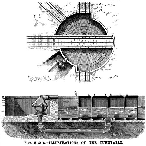 As said before, the road is designed
to be almost exactly straight, since there will be no curves having
a radius of less than twenty miles, for the carriage is four hundred
feet long, and rests upon wheels which, as already explained,
are not set on trucks swinging to a common center. There are only
five places in the whole line where it is necessary to deviate
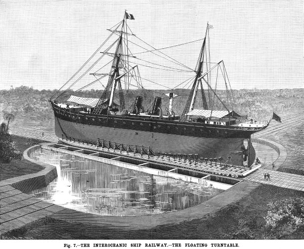
from a straight line, and at each of these places a floating turntable
(see Fig. 5 to 7) will be built. These turntables
in design resemble pontoons, for they rest upon water, and will
be strong enough to receive the carriage and its burden. The turntable-pontoon
will be firmly grounded, when the carriage is run upon it, by
the weight of water upon the circular bearers of the basin. The
water is pumped out by a powerful centrifugal pump, the water
being emitted through an opening in the cylindrical pivot of the
pontoon and discharged into the basin. Now, the pontoon has been
made sufficiently buoyant to be turned easily upon its pivot by
steam power, and the ship carriage is quickly pointed in its new
direction. The valves then permit the water to enter once more,
and the pontoon turntable again rests on its bearings. These turntables
may be made to serve another purpose. By their means a ship can
be run off on a siding, so to speak, where she can be scraped,
painted, coppered, calked, or otherwise repaired without removal
from her cradle, and thus be saved the heavy expense of going
on a dry dock. As said before, the road is designed
to be almost exactly straight, since there will be no curves having
a radius of less than twenty miles, for the carriage is four hundred
feet long, and rests upon wheels which, as already explained,
are not set on trucks swinging to a common center. There are only
five places in the whole line where it is necessary to deviate
from a straight line, and at each of these places a floating turntable
(see Fig. 5 to 7) will be built. These turntables
in design resemble pontoons, for they rest upon water, and will
be strong enough to receive the carriage and its burden. The turntable-pontoon
will be firmly grounded, when the carriage is run upon it, by
the weight of water upon the circular bearers of the basin. The
water is pumped out by a powerful centrifugal pump, the water
being emitted through an opening in the cylindrical pivot of the
pontoon and discharged into the basin. Now, the pontoon has been
made sufficiently buoyant to be turned easily upon its pivot by
steam power, and the ship carriage is quickly pointed in its new
direction. The valves then permit the water to enter once more,
and the pontoon turntable again rests on its bearings. These turntables
may be made to serve another purpose. By their means a ship can
be run off on a siding, so to speak, where she can be scraped,
painted, coppered, calked, or otherwise repaired without removal
from her cradle, and thus be saved the heavy expense of going
on a dry dock.
The locomotives for hauling the ship carriage over the Isthmian
railway will not differ from those in ordinary use. The big freight
engines of the day have no difficulty, as we know, in drawing
freight trains of a total of two thousand tons; and as the ship
carriage moves along three tracks it would be easy, if such a
course were necessary, to place three locomotives in front of
it and three behind. The time estimated for crossing from ocean
to ocean is only sixteen hours.
Having now been over the ground of the ship railway and examined
its several engineering features, let us turn to consider from
the same practical standpoint the plans on which it is proposed
to construct the rival projects at Panama and Nicaragua.
We have seen that, in the proposed Interoceanic Ship Railway,
no really new or startling engineering problems present themselves.
Is this the case with the canal projects? Let us see. At the International
Canal Congress in Paris, in May, 1879, the Panama plan was rushed
through despite the protests of the American and English delegates,
who insisted that it was altogether impracticable. A simple reconnaissance
had been made by Lieut. Lucien Wyse, and this was given precedence
by the French over the many and careful surveys which hove from
time to time been made by skillful American engineers and by engineering
expeditions from other countries.
It was evident from the start that the French had made several
serious miscalculations. They had not given sufficient weight
to the deadliness of the climate in that part of the Isthmus and
the extent of the floods—two factors, as we shall see, which,
if they do not finally prove an effective barrier to the progress
of the work, are sure to greatly retard it and render its construction
so costly as to make it, at the best, but a sorry venture from
a financial standpoint. When nearly two-thirds of the whole appropriation
for the canal was expended, and about one-thirtieth of the work
performed, a startling discovery was made. The course of a great
river, the Chagres, must be turned, and some means found of diverting
the mountain streams, before active work on the canal proper could
be resumed. Now, the Chagres River, so say expert engineers who
have been on the ground, will require an immense expenditure of
money—$20,000,000 at the least—to dam it at Gamboa,
and a dam 160 feet high; also a lateral chancel to divert these
impounded waters thirteen miles in length and as large as the
main canal, for there will be twenty million cubic meters
in it.
Some idea of the destructive power of the Chagres River may
be had from the fact that, in 1879, during an unusual freshet,
it flooded its entire valley for thirty miles; there being eighteen
feet of water on the line of the Panama Railroad. The lateral
canals for carrying off the water are likely to prove dangerous
as well as expensive. As to these Colonel John G. Stevens, of
New Jersey, one of the most eminent and experienced canal engineers
in the country, and who visited Panama some two years since for
New York capitalists, says: "Being situate in a depression
of the Cordilleras, and flanked on each side by lofty mountain
ranges, with steep sides, all water drains rapidly into the valley.
Then again the rainfall of the tropics is excessive, and with
us would be called phenomenal; at times being six inches in twenty-four
hours for days in succession. The river consequently rises rapidly,
and the greater part of the valley is submerged . . . . I think
I can say that but one efficient plan can be formed, and that
is to construct drainage canals on each side of the valley, so
as to intercept the water that will drain from the mountain ranges
on each side. Now, in severe floods the surface waters of these
canals will be about seventy feet above that of the canal proper;
consequently heavy guard banks will require to be constructed
to restrain these intercepted floods. In other words, the water
will have to be hung up on the sides of the mountains.
Of course, with such a pressure, there will always be a great
risk of the water breaking through the banks and the canal so
filled by sediment as to stop navigation until it is removed.
This would necessarily be a work of time, and destroy the prestige
of the canal as an avenue of transport . . . . I do not remember
ever to have seen money expended and such slight results effected;
but I wish to add that this was evidently not due to the gentlemen
in immediate charge, who were capable and zealous."
From evidence furnished by other expert engineers who have
visited this region, it may be safely predicted that the wash
from the slopes (clayey) in the profuse rainfall of this tropical
region will tend to fill up the canal and entail a large expense
in removing material.
The original estimate of the quantities of material to be removed
has, of course, been greatly increased by the proposed Chagres
River dam and the diverting channel back of it. Prices for labor,
since the deadliness of the climate has come to be realized, have
advanced to double and even thrice their original figures, and
labor which at first was had for 30 cents advanced last year to
90 cents; 10,000,000 cubic yards, mostly soft dredging in the
terminal marshes, has been done in four years. But even suppose
they can do 6,000,000 cubic yards of dredging and rock excavation
per year—and this is surely a generous estimate—then
198/6=33 years to complete the canal. The original estimate was
from $120,000,000 to $170,000,000, but with the obstacles now
in view, and considering that the rock work has hardly been touched,
$200,000,000 would seem to be a not unreasonable figure which
the work will have cost when performed.
Let us now turn to the Nicaragua scheme. This project is for
a lifting-lock canal—from 17 to 20 large locks being required.
The time necessary to cross from ocean to ocean would probably
be about three days. The location is 800 miles farther south than
Tehuantepec, and consequently far south of the shortest route
to California and the far East. It is situated also in the calm
zone and in a country frequently visited by earthquakes, and hence
liable at all times to serious injury.
The harbor of Greytown (north side) is irretrievably ruined,
and Major McFarland estimates that it will cost $14, 000,000 to
make a good harbor of it. The harbor of Brito, as it is called,
at the point where the Rio Grande enters the Pacific, is in fact
only a small angular indentation of the land, partially protected
by a low ledge of rocks, entirely inadequate for the terminus
of a transisthmian canal and incapable of answering the commonest
requirements of a port.
No reliable estimate of the expense of the Nicaragua canal
has fallen short of $92,000,000; the Government Commission estimated
$100,000,000, and Major McFarland $140,000,000. Capt. Bedford
Pim, M.P., who is but recently returned from Nicaragua, estimates
$200,000,000. The complication with England, too, makes the Nicaragua
route to a great extent objectionable. By the Clayton-Bulwer treaty,
made with England in 1850, we pledged ourselves to exercise with
her only a joint control over any canal that should be built at
this point, then looked upon as a favorable position for a canal
because at that time there was a good harbor at Greytown. (The
natural breakwater was destroyed by the sea in 1859, and the harbor
filled up and ruined.) Only two years ago, as we know, England
reasserted her claims, and insisted that the terms of the treaty
should be complied with. In the recent concession made by Nicaragua,
the government of the latter country makes the modest demand for
one-half the tolls collected, should the canal be built.
The cost of the ship railway as computed by expert engineers
will be about sixty million dollars ($60,000,000), or $75,000,000
at the outside.
A careful estimate has shown that it would not be unreasonable
to look for a gross tonnage of 5,000,000 tons in 1888 for any
passage across the Isthmus. Four dollars the ton would be but
a moderate charge—the Panama Railroad demands $15 a ton.
This would give $20,000,000 as gross receipts. Now, it has been
estimated that 50 per cent of this would pay all working expenses,
thus leaving $10,000,000 as net profit, or 10 per cent on a capitalization
of $100,000,000.
The Tehuantepec ship canal is a private enterprise that does
not ask a dollar from the government, and there will be little
trouble in its construction if the government does not by legislation
or by committing itself to the Nicaragua canal scheme injure its
prospects and defeat its aim, which is to furnish a cheap, rapid,
and safe passage for ships across that narrow strip of land which
heretofore h a s proved an effectual barrier to aspiring canal
builders. The promise of an original undertaking may be said to
be directly as its author has succeeded or failed in previous
enterprises, and hence it is but natural that the reader should
like to know something about Mr. James B. Eads.
Ten years ago the bars at the mouths of the Mississippi below
New Orleans had approached so near the surface that it looked
as though the great city of New Orleans would be open in the near
future to nothing larger than sloop navigation. A gradual shoaling
had been going on for years, and various devices were suggested
for deepening the channel, but none of them seemed to offer any
hope of success. At last two bills were introduced into Congress
relating to this subject.
One of these came from the headquarters of the Engineer Corps
of the army, and advocated the construction of the Fort St. Philip
Canal, leading from the river to the adjacent bay, about forty
miles above the mouth of the river. The second bill was presented
in behalf of Mr. Jas. B. Eads, and contained a proposition for
improving the mouth of the river by means of jetties. This proposition
met with strong opposition, and army and civil engineers vied
with each other in demonstrating its wanton absurdity. Mr. E.
L Corthell’s paper on "The South Pass Jetties,"
read before the American Society of Civil Engineers, says:
"The propositions enunciated by the Board of Army Engineers
and by the Chief of Engineers, on which they based their published
prophecies of failure, were:
"First.—That the jetties would be undermined
at the sea ends.
"Second.—That the foundation on which they would
rest was unstable. And
"Third.—That there would be a greatly accelerated
advance of the bar after the jetties were constructed.
"Three positive opinions were given in official reports
by three prominent United States engineers—one the then Chief
of Engineers, another the present Chief of Engineers, and the
third the officer in charge of the improvement of the Gulf ports—in
reference to the rapid and accelerated growth seaward of the bar
in consequence of jetties, which would produce a depth of from
25 to 27 feet, if such could be constructed. These gentlemen respectively
gave as the annual rate of advance, after the construction of
jetties at the mouth of the South Pass, 670 feet, 2,240 feet,
and (in the language of the third) ‘jetties will have to
be built, further and further out, not annually, but steadily
every day of each year, to keep pace with the advance of the river
deposit into the Gulf, provided they are attempted."’
Of this ponderous opinion Mr. Corthell remarks, with something
very like sarcasm:
"The necessary extension of the jetties into the Gulf with
these rates of bar advance would have been up to this date respectively
three-quarters of a mile (to where there is now actually 160 feet
depth of water), two and one-half miles, and well out toward Cuba."
Mr. Eads finally succeeded in convincing Congress that there
was at least something in his scheme, and he was given the contract,
with the proviso that he should not be paid until he had secured
the depths and widths of channel specified in the contract.
When he undertook the work, the depths in the crests of the
bars in the Gulf, outside of the land, were 13 feet at the Southwest
Pass, 11 feet at the Pass a Loutre, and 8 feet at the South Pass,
all measured at mean low water. From the very inception of his
jetty system it was a remarkable success; the South Pass deepened
more and more by the scour of the river, until upon its shoalest
spot he had 30 feet of water—a depth it maintains to this
day, when the Great Eastern, the largest ship in the world, is
able to cross the spot where, ten years ago, there was only 9
feet of water.
The fame of Mr. Eads, and his new interpretation of the Old
World’s jetty system, soon became an absorbing topic among
hydrographers and engineers far and near. The Prince of Wales
himself presented him with the Albert medal. This medal is inscribed:
"Captain James Buchanan Eads, the distinguished American
engineer, whose works have been of such great service in improving
the water communications of North America, and have thereby rendered
valuable aid to the commerce of the Old World."
It is the same man who has projected the ship railway across
the Isthmus of Tehuantepec, and if his plans are not thwarted
by unwarranted government interference, there is reason to believe
that ere yet the graceful masts and trailing yards of majestic
ships will be seen to mingle with tropic palms in the mountain
fastnesses of the Cordilleras.
In our illustrations, Fig. 1 shows an elevation of the
adjusting of the screw standard for supporting the vessel on the
pontoon, the detail of these standards being given in Fig.
4. A is the standard, having a head plate with universal
joint, its top cushioned with rubber or canvas, to prevent damage
to the ship; B is an adjusting nut, which, when the rams
are down, stops the descent of the jack by contact with the top
side of the main girder, C, on which they will rest, D
being the top of the hydraulic jack of the pontoon, the number
of these jacks used being better shown in Fig. 3, a section
of the floating pontoon. E F G, in Fig. 2, show
the sectional girders by which the weight of the vessel is distributed
on the jacks. H shows one of the upper pontoon sections.
J shows arrangement in connection with the pump on pumping
tower, L, to distribute the load of the vessel equally
on all the jacks. I and K show the arrangement by
which the water is exhausted from the pontoon. On each side of
the basin there are several rods on top of which are nuts capable
of holding the pontoon, to prevent its rising above the level
of the railway when the ship and cradle have been taken off. Figs.
5 and 6 show a plan and sectional view of the floating
turntable, and Fig. 7 a perspective view, with ship on
the turntable.
Panama Canal
| Contents Page
|