The Costliest Railroad
in America
A New Railroad That Cost More Than Thirty
Million Dollars
by J. O. Lewis
Scientific American Supplement No. 1752—July 31, 1900
Bird's Eye View of Unaka Springs, Tenn., on
the new Carolina, Clinchfield & Ohio Railway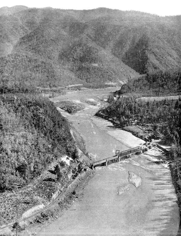
This is the story of a great railroad. It is the Carolina,
Clinchfield & Ohio Railroad, just completed from the great
bituminous coal fields of southwestern Virginia and eastern Kentucky
to the cotton mill district in South Carolina. The promoter and
builder of this magnificent road is George L. Carter. To-day it
stands as a monument to his genius—one of the greatest pieces
of railroad construction east of the Rocky Mountains.
It is the only road which crosses the entire Alleghany Mountains
at their widest part transversely, or at direct right angles with
their parallel ranges. Rising from a few hundred feet above the
level of the sea to 2,629 feet, at the highest point, where it
crosses the Blue Ridge Mountains, exceptionally low grades have
been maintained. From Dante, Va., the present northern finished
point, to Bostic, N. C., its present southern terminus, the distance
is 211 miles; and for the distance it contains more tunnels than
any other road in the country. There are thirty-five tunnels,
six important bridges, and many very large cuts and fills; but
in the main, bridges and trestles have been done away with, and
wherever possible, replaced by fills.
Take a map showing eastern Kentucky, southwest Virginia, eastern
Tennessee, and western North Carolina; then locate Elk Horn City
in Pike County, Kentucky, near the Virginia line, which is the
nearest town of any size to Dante, Va.; next draw a straight line
through to Marion, N. C., via Johnson City, Tenn., and you have
the route of the C., C. & O. Railroad—directly across
more mountain ranges than any other section in the Alleghany system.
The purpose of the road is to furnish an outlet for the product
of the Clinchfield coal mines, principally to the southeast Atlantic
seaboard, nearest the Panama Canal and southern coaling stations.
The original Idea and purpose of George L. Carter, president
of the road, when he purchased the unprofitable line of the old
"Three C's" in 1901, which ran only from Johnson City,
Tenn., to Huntdale, N. C., was to extend it into the great bituminous
coal fields of southwest Virginia and eastern Kentucky; and to
make it the best ballasted, safest, and largest coal-carrying
read in the United States.
Looking backward into the history of the old "Three C's"—Chicago,
Cincinnati & Charleston Railroad—we find that the promoters
of this road were Gen. John T. Wilder, now living at Knoxville,
and Frank Stratton, a Virginian. Their idea of constructing the
road was to build a trunk line from Chicago to Charleston, and
put it on foot in 1882. Within two years a line was constructed
from Allison's Mills, Tenn., on the Wataguga River to the North
Carolina State line, a distance of about thirty miles. In 1890
it went into the bands of receivers, and was sold to Samuel Hunt,
then president of the Cincinnati, Portsmouth & Ohio Railroad.
That portion of the line from Allison's Mills to Johnson City
was torn up, and the material used to extend it farther south,
and to a station called Huntdale, named for the president. In
1901 George L. Carter purchased this short line, reorganized it,
and changed the name to the South & Western. With Mr. Carter
the road was to be but the means to an end. He had early inspected
and practically gone over every foot of the route, was familiar
with the topography of the country, knew of and realized the value
of the mineral deposits, had located every tract of timber, and
figured out the possibility of big returns in its development.
He took his proposition to New York and interested capital.
The services of M. J. Caples, an expert civil engineer and practical
railroad builder, were secured, and the plans begun for building—which
has been proven—one of the best and most costly railroads
for the distance in the United States. Not costly in the meaning
of extravagance, but costly from physical necessity, for the greatest
experts of the country say that it has not cost a dollar too much.
The actual building began in 1903, and was finished in November,
1908.
Instructions were given to the engineers that surveys be made
which would give the road the lowest possible grade and yet the
shortest route to the coast. To do this was the riddle which has
just been solved in the finishing of the line from Dante to Bostic.
In celebration of its completion, the Commercial Club of Johnson
City, Tenn., gave a large banquet to the officials, which was
attended by many prominent men of the country, including W. W.
Finley, president of the Southern; F, P, Howe, Philadelphia, president
of the East Tennessee & Western North Carolina Railroad; and
presided over by Congressman W. P. Brownlow of the First Congressional
District of Tennessee as toastmaster.
To handle big trains of large cars of coal meant to do away
largely with trestles and bridges and to substitute fills wherever
possible, and to build a low-grade road. As a result there are
not more than a half dozen bridges, and the grade maintained is
a compensated grade of less than six-tenths of one per cent a
mile over the summit of the Blue Ridge. Bridges were built only
where it was impossible to make fills.
From Dante, Va., to Bostic, N. C., a distance of 211 miles,
there are thirty-five tunnels, the sum total of the lengths of
each making more than seven miles of underground travel. The longest
tunnel on the line is through Clinch Mountain, bearing the same
name. It is 4,200 feet long, and cut through solid rock the entire
length. It took more than two years to drive it and cost over
two million dollars. The next longest tunnel is right on top of
the Blue Ridge Mountains at Altapas, N. C., and is known as the
Summit tunnel. This tunnel is more than a half mile long, and
is 2,629 feet above sea level. From Spruce Pine, two miles west
of Altapas, to Marion, N. C., there are twenty-odd tunnels.
After passing through the Summit tunnel, the line makes an
eight-mile loop, returning to within four hundred yards of the
south end of the tunnel, but three hundred feet lower down. In
this eight-mile loop there are nine tunnels, and from within twenty
miles of the Summit tunnel there are nineteen tunnels. A very
important feature about the tunnels on this line is that every
one is cut high enough to permit the tallest man to stand on top
of a box car as the trains pass through. From the 211-mile post
on the west side of the Blue Ridge to the 231-mile post on the
eastern slope, the rise or fall vertical is 1,160 feet.
The cuts and fills are almost innumerable, while some of them
are the largest and deepest to be found on any road east of the
Mississippi River. The highest trestle is over Copper Creek in
southwest Virginia, and is known as the Copper Creek viaduct.
From the surface of the stream to the track or rails on top of
the trestle the height is 185 feet, and its length is 1,160 feet.
Another very high bridge is over Holston River, one of the headwaters
of the Tennessee, the height of which reaches 100 feet. The largest
and deepest fill on the line is known as the Knob Creek fill,
being 85 feet deep and three-quarters of a mile long, requiring
more than a half million yards of material to fill up to grade.
The next largest fill is over Gate branch, which reaches a depth
of 135 feet and 1,200 feet long. The Big Poor fill is another
one of considerable cost. This fill is a mile long, and required
more than 200,000 cubic yards of earth.
The largest and most important cut on the road—and said
to be the largest on any road in the South—the Soldiers'
Home cut, located right at the junction of the Home grounds and
the Southern Railway. This cut is 85 feet deep, a mile long from
grade ends, and required the removal of more than 500,000 cubic
yards of dirt, most of which was used to make the Knob Creek fill,
which is only two miles distant.
The most rugged and picturesque portion of the road is that
part which runs from Johnson City south across the Blue Ridge
Mountains to Marion, N. C., and known as "The Land of the
Sky." Beginning at Unaka Springs, twenty miles south of Johnson
City, the road enters and runs through the famous Nolachucky Canyon,
said to be the grandest outside of the Grand Canyon itself. Like
a serpent for nearly twenty miles, this road winds its way through
chasms, gorges, ravines, between towering cliffs and mountains
extending upward thousands of feet.
After leaving Altapas and the Summit tunnel for about four
miles, the line passes in full view of Mount Mitchell, the altitude
of which is 6,711 feet above sea level.
"Twelve miles from this point is Linnville Falls Station,
from which Linnville Falls, N. C., a noted summer resort, is reached
in covering a distance of six miles by stage. This is a charming
resort, high above the clouds. From this point can be seen twenty-one
peaks higher than Mount Washington, and forty-eight that overtop
Mount Adams. The stage route from Linnville Falls Station on the
C., C. & O. Ry. passes through some of the wildest scenery
of the South; vast chasms, ghastly rents, massive towering rocks,
seared and seamed, are on every hand. At this point a stream dashes
over a steep, broken cliff some hundred feet high. There is most
excellent trout fishing to be had at this point." (Charles
T. Mandel in Appalachian Trade Journal.)
Where the famous loop is made on the eastern slope of the Blue
Ridge, there are three complete views of the track on one mountain
side as it winds its way back and forth to make the grade. This
is said to be the most remarkable loop on any road in the United
States. This feature was considered practically impossible at
one time; but the courage of the owners and the skill of the engineers
accomplished the miraculous, and have proved nothing impossible
in railroad building.
Standing at the mouth of Summit tunnel, one can see the train
as it winds its way around the mountain sides, through many tunnels
and cuts, crossing the valleys, puffing and blowing in the climb,
for thirty-five minutes before it reaches you. Fourteen different
views of the train are presented in this scene. Across the valley
on the side of another great mountain can be seen the three Washburn
tunnels in straight line, and to stand at either end, one can
see through all three of them. It is indeed a spectacular sight,
and with perhaps but few exceptions, unequaled on any road and
anywhere.
The Blue Ridge section is one of the richest in iron, copper,
mica, kaolin, manganese, limestone, and timber in the whole Appalachian
region, if not in the whole country. Southeast of the Blue Ridge,
and embracing part of it, lies the Piedmont section, stretching
out into the great southeastern cotton mill district; and through
the very heart of these penetrates the Carolina, Clinchfield &
Ohio Railway. With such immense undeveloped wealth, together with
that which is just yet in the embryonic and nursery stages, no
one can gainsay the wisdom prompting the vast expenditures made
in the development of this road and its co-related interests.
The average cost per mile of the C., C. & O. Railway has
been upward of $125,000.
From Bostic, N. C., to Spartanburg, S. C., the building is
well along toward completion, and by October next through trains
will be running into Spartanburg.
To give one an idea of the economic considerations entering
into the future management of the road, we will state that the
road is now hauling in one train from the coal fields at Dante
through to Bostic, with one engine, what it takes the Seaboard
to haul out of Bostic in three loads. These large engines were
made by the Baldwins.
Three Tunnels,
One Showing Through the Other
Local Freight at Guest River, Va.
Bridge at Unaka Springs, Chuckey River.
Four Spans 117½ Feet; Three Spans 70 Feet
Copper Creek Viaduct, 185 Feet High,
1,160 Feet Long
Eagle Cliffs in the Gorge of Chuckey
River
The Sandstone Bluffs Along the Clinch
River on the Edge of the Coal Fields
Devil's Backbone in the Center, which
is the State Line Separating Tennessee and North Carolina
The Catawba River Viaduct
The Fill Over the Holly Spring Branch
Making the Roadbed Along the Cliffs
of Clinch River Above Clinchport, Va.
Bridge Across the North Fork of the
Holston River
Soldiers' Home Cut, 85 Feet Deep,
One Mile Long, at Johnson City, Tenn.
Stories Page | Contents Page
|