| In Memory Of: Hazel Osborne (daughter of Lester Davis and Bessie Bishop) June 8, 1909-October 28, 1997
Check out the online, annotated slideshow, with commentary on historical context by Camilla Calhoun.
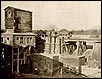
"The site of Bishop Falls
now lies 1/4 mile from the main Ashokan dam under 180 feet of water at the deepest part of
the reservoir."
"Blinded from smallpox at four, Jacob Bishop "the blind miller" became a local legendary
character."
"Imagine the once tranquil Esopus valley transformed by
the building of the Ashokan dam and
reservoir."
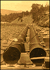
"A concrete mixing station
was built for the blocks of the dam."
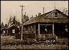
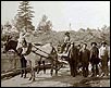
"Villagers were inundated with more than noisy
construction, as 3,900 workers descended upon
the rural valley." "While the Croton Dam was built mostly by Irish laborers, the
Ashokan was built by Italian immigrants and
African Americans from the south."
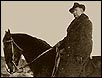
"One of the foremen running the operations would survey the work from horseback."
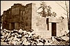
"This tower was built as a
memorial for George McLellan, the Mayor who made the expansion into the
Catskills possible when his bill passed the Legislature."
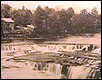
"When the reservoir is full it looks like a natural crater lake nestled among High Point and other Mountains."
|
A Town Called
Olive: A Perspective on New York City's Water Supply By
Camilla Calhoun On the way to my cousin's burial in Olive Bridge, New York, the funeral cortege made a special turn by the Ashokan Reservoir to file past the New York City Water Works Department where my cousin, James McGloughlin, had been employed for the last thirty years. Like a long, segmented train, we inched down alongside the cement frame of the great fountain aerator for the Ashokan reservoir. The silence and the stillness of the aerator seemed appropriate for the occasion. Looking out the car window, childhood summer visits to my grandparent's farm flashed before me, with memories of watching the aerator's 1600 powerful fountains spouting water twenty to thirty feet up in the air. I became flooded with the realization of how my roots are connected to a place I knew little of, to a fertile, fully inhabited rural valley which was inundated in 1912 to create a reservoir to supply New York City with drinking water. Soon after returning from the funeral, I began dredging up the story of the forgotten Town of Olive. That story became linked to New York City's historic quest for clean and abundant water. As I learned of the expansion of the New York City population, I began to envision the movement and confinement, use and abuse of the same water supply system on which millions of New Yorker's lives depend; that history sheds light on the current efforts to protect the watershed which supplies New York City with drinking water. Wherever human populations have settled, their first challenge has always been to find a fresh supply of water. Civilizations have flourished thanks to one river or another. As witnessed by what was once the "fertile cresent" which became a desert through human use, the destruction of a civilization may also rely on how wisely land and water is used. In 1625 when the Dutch settled in "New Amsterdam" the inhabitants depended upon surface waters from springs, ponds and streams, including a 48 acre, 50-68 feet deep "Ketch-Hook" pond, located in the area which is now spanned by the paved streets from Pearl to Franklin Street in Manhattan. By 1658 private wells were constructed south of Wall Street to supplement the supply for the 300 New York City residents. With the English occupation, the population rose to 1,500 and the first stone-lined wells were dug in Fort New York. Digging began at the original site of City Hall for these public wells, but being "low-lying and marshy," Manhattan's wells were soon contaminated by salt water intrusion. Unsanitary conditions and the general filthy state of the city was reflected in the water quality, where sewage from cesspools, privies and street drainage fouled the water. By 1748 locals claimed that "not even the horses would drink the stuff. " The first water distribution system was built in 1774 and consisted of a network of wooden pipes, wells, and a pond on Chambers Street which served as a reservoir. However, the Revolutionary War stopped the progress and completion of this project. By 1800 the city's population had swelled to 60,000. With the yellow fever epidemics of 1798 and 1799 serving as a catalyst, the city commissioned the Manhattan Company (spurred by Assemblyman and part owner Aaron Burr) to supply "pure and wholesome water" to New Yorkers, a plan which failed through poor service and corruption. The intention of the Manhattan Company was to use the opportunity of water supply to establish a bank. Their remaining legacy is the Chase Manhattan Bank. By 1830 the New York City population of 200,000, still without a sewer system, depended on a groundwater supply said to have been polluted with 100 tons of excrement daily. Greenwich Village, considered a country escape from the city during the yellow fever epidemics of the late 1700's, was settled by 100,000 residents who, fleeing the water-related cholera epidemic of 1832, moved their homes from south Manhattan to find clean water. Just three years later, when further groundwater contamination occurred, the Manhattan Common Council approved for the first time a plan to tap a source of water outside the city. By 1842, new technology and the use of iron pipes made the project to dam the Croton River of Westchester County possible. However, New Yorker's celebration of "pure" water was fleeting. The city's population grew from 300,000 in 1842 to 1.2 million in 1883, making the Croton supply already insufficient. Some improvements were made in the 1850s through the 60s when flush toilets and a city-wide sewer system was established. However, as the Croton system expanded, so did the city's population, reaching 3 million by 1910. The city of Brooklyn, which was then independent, began the momentum to tap the Catskill Mountains for water. Once New York City expanded its boundaries to include Staten Island and Brooklyn in 1898, the push for a new water supply source was officially on. In 1905, the legislature passed Mayor George McClellan's bill which allowed him to form the Board of Water Supply and begin the action to find a reservoir site. City surveyors, ignoring the rights of property owners, fostered animosity among the rural communities that were to be sacrificed "for the needs of the great city. " Distinguished engineer John Freeman was commissioned to investigate possible water sources. The valley of the Esopus River in the Catskills was chosen as the site, although Freeman reported it was not his first choice, since it meant flooding out the "thriving village of Shokan... and the present railroad location...with great disturbance of population and flooding of a large portion of all the good land in the valley. " The main occupation of these rural communities was farming, but businesses such as logging and bluestone quarries were also found in the valley. The finest bluestone from the town of West Hurley was used to pave some New York City streets and in the construction of the Brooklyn Bridge. It was Brooklyn's joining the city of New York which clinched the need for a new reservoir site. So there is irony in the drowning out of West Hurley, the town which provided raw materials for building the bridge from Brooklyn to Manhattan. Solid bedrock, which promised protection from leakage, won out over the fight for the fertile esopus valley. John Freeman's test borings suggested the high dam be built at Bishop Falls. The first contract was signed on April 10, 1907, for an eleven mile stretch of Catskill aqueduct. That same year the main dam at Olive Bridge was contracted. For the next ten years, work on this reservoir system proceeded to completely change the face of the "Gateway to the Catskill Mountains." Bishop Falls, once a famous landmark in the valley, now lies about 1/4 of a mile out from the main dam under 180 feet of water at the deepest part of the reservoir. It marks the spot where the Esopus Creek was stopped on September 9, 1913, and where water storage began in the west basin of the Ashokan Reservoir. The falls were named for my ancestor, Asa Bishop, born in 1753 in Nine Partners in Dutchess County. He came to the town of Olive in 1790 and built a stone house above the falls where he erected the mill. About the same time Aaron Burr's Manhattan Company was commissioned to find pure, wholesome water, Asa was working his grist mill. His son Jacob was born there in 1794. Jacob, blind from smallpox at four, later became a local legendary character known as the "Blind Miller", who was reported to know the color of a horse by touch, and his customers by their voice. Jacob and his wife Ernestine had 11 sons and 1 daughter. One of their grandsons was Ephraim Bishop who owned a bluestone quarry in the Esopus valley and set up a general store and a post office. The youngest of Ephraim's and his wife Eliza Ann Wood's eight children was my grandmother Bessie, born October 5, 1877. There is a photograph I have always seen on the walls of my grandmother's home in Olive Bridge. There is Bessie as a young woman in her white blouse standing with her parents outside their home, which according to the town historian Vera Sickler, was the first to be condemned by the city to build the Ashokan reservoir. Imagine the logistics of getting 2,000 people, some who had lived there for generations, to move from their homes in this lush, fertile valley at a time when transience was uncommon. One thousand New York City residents who had second homes there, also lost their homes. Located in the valley, among other things, were 35 stores, 10 churches, 10 schools, 1 gristmill, and 7 saw mills. In order to begin the exodus from the valley, the Commissioner of Appraisal had to post notices warning property owners "that in less than two months title to their property would be vested in New York City and they would be subject to a ten-day notice to move. " The state Water Commission had supported the plan despite the fact there were hearings and residents fought the city's plans with capable lawyers. The city looked on the project as a sort of heroic feat, the challenge of Man, once again, triumphing over Nature. No one seemed to consider the anguish imposed on the inhabitants of the valley who had lived there for generations and were connected to the land in a way which few urban dwellers understand. "How can they be allowed to take our home?" was the question my grandmother continuously asked her father Ephraim Bishop. No compensation made up for the loss felt by the communities in the valley. When actual claims were processed, they took months to years and were handled in an arbitrary manner, without set guidelines regarding property values. Details regarding the trials of these displaced residents came from references to a book "Water for a City" written by Charles Weidner. A familiar name, I thought. Could the author be the uncle I never knew, the man who was once married to my Aunt Mabel? My Aunt Hazel confirmed the connection, and although the book was out of print, my cousin Winifred sent me a copy of her father's book. "A woman with 21 acres of land and a boarding house was awarded $6,500 while another with a half acre and a small house was awarded $4,000." According to Weidner, business claims were also unfairly paid. "Mrs. Emma Cudney received only $8,707.50 for the loss of her 20,000 ginseng plants.... In 1909 Ginseng was being sold for $6-$7 per pound. " While these claims moved extremely slowly, construction of the reservoir progressed at an incredibly fast pace, including the building of a village camp for the immigrant laborers. The 3,900 laborers outnumbered the inhabitants of the valley, which also was a factor in the displacement felt by the local residents. While the Croton Dam in Westchester County was built mostly by Irish laborers, the Ashokan was built by Italian immigrants and African American workers from the south. Many of the men working on the reservoir had families. Two segregated schools were built for their children, one for the Italians and one for the African Americans. Many of the laborers carried weapons. Fights broke out on a regular basis, with several fatalities. The watershed police, whose job today is to protect water quality, was originally established to protect residents and keep peace in the labor camps. The building of the reservoir required enormous labor and machinery. The transformation of what was once a tranquil rural valley became a noisy, unsightly, gigantic manufacturing zone with steam shovels, rollers, derricks, cement mixers, stone crushers, with "dirt trains" and mules transporting all the materials out of the excavation site. Before the city flooded the valley, thirty two cemeteries with 1800 bodies had to be removed in order to prevent water contamination. The city paid relatives $15 to move the graves and $3 to remove and reset headstones. The Ashokan Dam was built by Winston & Company, Katonah builders of the New Croton and Cross River dams in Westchester County. All three of their dams were constructed with the same utilitarian concrete blocks. A more intricate, labored tone was taken for the blocks of the Kensico Dam, which serves as the receiving reservoir for all Catskill and Delaware water for New York City. Rather than concrete, the imposing Kensico Dam wall was built with granite stones, cut and decorated by masons working over two years on the project. The Kensico Dam became a showcase for New York City dwellers who would meander up from the city to Valhalla on the newly built Bronx River parkway. The Kensico Reservoir began receiving Catskill water on November 15th, 1915, driven 125 miles entirely by gravity. The approach to the Kensico Dam is a very different experience than the approach to the main Ashokan Dam. The great expanse of Ashokan water appears, when full, like a natural crater lake nestled in the Catskill valley. A dividing weir and a 15 arch bridge separate the east and west basin. It seems unreal to think the town of Olive was once under those waters. But Olive was only one village destroyed to form the west basin of the reservoir. West Shokan, Brodhead Bridge, Brown Station and Boiceville were also once located there. The east basin displaced the villages of West Hurley, Glenford and Ashton. In 1913, when my mother was 4 months old, born a few miles away from the reservoir, the city began filling the west basin. While water was filling the east basin two years later in 1915, the west basin was already being used to test the aqueduct to New York. From the Catskills the water traveled 125 miles to empty into the Kensico, then down to the next receiving reservoir, the Hill View in Yonkers, and on to the Silver Lake on Staten Island. All boroughs of the city were receiving Catskill water by 1917. On October 12, 1917, the NYC Board of Water Supply celebrated the "good gift of water" for three days. At the upper Central Park reservoir a fountain displayed Catskill water with a jet rising over 100 feet into the air. The chief engineer of the project, J. Waldo Smith reported that work on the Ashokan reservoir and aqueduct had been completed a year ahead of schedule and was also $7,000 under the estimated cost! By itself the Ashokan reservoir, 12 miles long and 40 miles around, with a 130.5 billion gallon capacity, was reason enough for the city to celebrate. However, construction of the aqueduct was perhaps even more impressive from an engineering perspective. A siphon was forged under the Hudson through solid granite, 1,114 feet below sea level. This tunnel still carries water from the west side of the Hudson 5.5 miles from Storm King mountain to Breakneck Mountain on the east. According to Charles Weidner it was the greatest siphon built by man at the time and, as an engineering feat, second only to the building of the Panama Canal. However, after the Ashokan was finished, the Catskill system was still insufficient for New York City. In 1917 the village of Gilboa on Schoharie Creek was acquired, with 192 parcels and an area of 2,435 acres to build the Schoharie reservoir. When the 18 mile Shandaken tunnel was built, it was the longest continuous tunnel in the world at the time, connecting the waters from the Schoharie into the Esopus Creek and then into the Ashokan Reservoir. In 1931, when the rate of the city's water consumption was increasing to 42 million gallons a day, a landmark Supreme Court decision permitted New York City to tap the Delaware watershed. That system developed in phases, the first being the Roundout reservoir, completed in 1944, the second the Neversink and Pepacton in 1953 and 1955, and the Cannonsville in 1965. The complete Catskill/Delaware system now supplies 90% of New York City's water and covers a land area six times that of the city. The story of the displacement of those residents is yet another saga in the search for a water supply for a growing city. Today, gazing over the glistening surface of Ashokan Reservoir water, it is difficult to imagine that only eighty some years ago children played there or that farmers tilled the land which is now full of drinking water. Yet in the drought of 1985, The New York City District Engineer took a few old residents down into the reservoir and rediscovered the foundations of their West Hurley homes. The old bluestone plank road reappeared, its wagon wheel ruts marking the way from West Hurley to the town of my mother's ancestry, Olive. Some of the former residents of the valley that lay below the Ashokan Reservoir moved to other states. Others resettled and rebuilt their villages around the reservoir. My Grandmother, whose parents died shortly after the reservoir was completed, lived with her husband Lester Davis, a dairy farmer in Olive Bridge, formerly called Tongore, named after an Esopus chieften rumored to be buried on their property. After my Uncle died, so went the dairy farm and, like many others in Ulster County, all that is left is an abandoned barn and a few memories, with occasional new housing marking the landscape. But the old house still stands, where my mother and siblings were born, and where my Aunt Hazel lived until her recent death. Every year since 1913 there has been a "Boiceville Reunion" on Labor Day, an event held for those families who had been forced off their land. Vera Sickler, who I interviewed in 1992, was then one of the few remaining survivors of that era. She recalled going to the first reunion with her father when she was ten years old. When work began on the reservoir she was a baby and twelve when it was completed. In a magnanimous moment in 1993 she said "I'm not bitter...life goes on" and, she added, "the Ashokan Reservoir is now a great attraction for tourists." Before the 1953 watershed regulations were updated, she wondered, "with all the development, is the city taking enough care of their resource?" That thought was strange, for most Catskill residents would like to have the city stay off their land and out of their business. Yet her question became a critical one in the l990s, one which had been sorely ignored. How to protect water quality at its source in the Catskill/Delaware basin and how to do that when most of the residents there held animosity and distrust for the city. When the water flows freely, New York city residents have always taken that gift for granted with unleashed water consumption. However, in 1985, when reservoir levels were frighteningly low, city residents responded to the crisis by rallying around the drought measures. That summer at the Boiceville Reunion Mayor Koch sent a message from New York City: "The aqueduct system that supplies water to New York City is one of the wonders of the modern world...It is appropriate indeed to remember...the sacrifices of our fellow New Yorkers upstate who helped make our water supply possible. Every day of the year since 1905 the people of New York City have raised their glasses in a toast to you - and in those glasses is the best water in the world." Meanwhile Mayor Koch directed his efforts regarding water towards quantity rather than assuring that the water would remain the "best". In fact, since the reservoirs were completed, New York City had almost always focused on the supply side with regard to its drinking water, on engineering and tunnel maintenance, without too much concern for the long- term preservation of quality. There seemed to be no need, with undisturbed soil and wetlands naturally filtering and draining rainwater and groundwater as it passed along. The distance the water travels from the Catskill mountains towards the city's faucets, and the very scale of the system has been a water quality safeguard, allowing "disease-producing organisms, or pathogens, to die off or settle out in the massive reservoirs used for collection and storage" according to engineer Thomas Cahill. However, with increased development, when it rains the water running off impervious surfaces carries a vulgar array of pollutants: motor oils, road salts, fertilizers, herbicides and pesticides, not only from farms but actually in greater amounts from lawns and golf courses. Over the last twenty years the areas upstate which were once rural and pristine, have also seen a rapid growth in population. In the Delaware/Catskill watershed area there was a 15% increase from 81,260 in 1970 to 93,400 in 1985. Yet, my cousin Skip Weidner, who is on the Planning Board in the Town of Olive, says that many people are moving out, "homes are for sale all over the place since IBM closed down in Kingston." However, even a census won't reveal that the whole watershed is a second home market. In the Town of Olive almost 40% of property owners are second home owners, who are not registered to vote there and are not around to be counted in an April census. Following The Federal Safe Drinking Water Act of 1986, the EPA began to pressure cities to protect their water quality. The EPA has stated that municipalities can avoid filtration plants if they show they are adequately safeguarding their watersheds. Following that mandate, the Dinkins administration moved more aggressively towards watershed protection than former administrations. It became increasing clear that a water system which supplies nearly half the state of New York with drinking water, with overall consumption in 1990 at 1.5 billion gallons daily, needed attention not only to quantity but to quality. In 1990, the city's Department of Environmental Protection, under the auspices of Al Appleton, drafted renewed Watershed Rules and Regulations, which had not been updated since 1953 and dealt mostly with rural impacts. Mayor Dinkins vowed to support antidegradation, the policy of preventing decline in water quality. Part of the city's incentive for protecting the source is an economic one: to avoid filtration of the Catskill/Delaware water, which will cost New Yorkers from $6 to $8 billion, with an annual maintenance of about $300 million. Across the Hudson in Westchester County, the Croton system, which supplies New York City with 10% of its water, has seen a population growth in its watershed of 39% from 231,250 in 1970 to 322,550 in 1985. With such fast rates of suburbanization and unprevented pollution, the Croton supply, thought to be degraded, was given the EPA order to be filtered. Construction of a Croton filtration plant is now on hold as groups lobby instead for watershed restoration and protection. In the efforts to avoid filtration and protect the Catskill/Delaware source, once again the city had to deal with the watershed towns west of the Hudson, with people who remember the stories of relatives forced off their lands by the city. In fact, the original draft regulations were so unpopular upstate that the towns west of the Hudson moved swiftly to organize themselves into a "Coalition of Watershed Towns." As a result, in 1992 "Whole Community Planning" was proposed, allowing the upstate towns to come up with their own watershed protection programs. This occurred after the DEP worked with the agricultural community in 1991 developing "Whole Farm Planning", which encourages farmers to participate voluntarily to control pollution. When Rudolf Guiliani became Mayor, he appointed Marilyn Gelber as DEP Commissioner, who spent countless hours up in the watershed area talking to residents. As she found herself "fencing with ghosts" in her dealings with the people west of the Hudson, she realized "the next generation demanded that we do things differently." She felt that in order to come to any subsequent agreement she had to "change the landscape from hostility and distrust to one of trust, respect and credibility." Catskill resident Eric Greenfield, Executive Director of the Coalition of Watershed Towns, who answers to 35 towns, was very disturbed that Gelber was replaced as DEP Commissioner since she had made such inroads acknowledging the history. Asked to characterize the sentiment regarding the partnership with the city as of the summer of 1996, Greenfield responded: "guarded optimism." He explained that the the city had a track record of unfulfilled promises. An example was the city's watershed roads, left in disrepair. He was encouraged to say the highway maintenance program had come through and said the city council was working closely and cooperatively to make the package that will not only help with economic sustainability in the area, but will begin to heal the old wounds. The 1996 Watershed Memorandum of Agreement consisted of a number of parts working together: land acquisition, watershed regulations, watershed protection partnership programs and the partnership council. Originally the EPA mandate for filtration avoidance was that the city acquire 80,000 acres. Although the DEP program clearly stated that acquisition would occur only from willing sellers, the fixed number infuriated upstate residents bringing back the fear that the city would use its power of eminent domain to get to that number. Residents wanted to know on what science the amount of acreage was based and Gelber had to admit that there was No rational response and that the figure was arbitrary. " A GIS (Geographic Information System) analysis consequently outlined the natural features in the Catskill/Delaware basin, and priority areas were selected according to their environmental sensitivity, which created a real land use review process to protect the watershed. The 80,000 requirement was changed, thus appeasing the opposition west of the Hudson. Still, the city has committed $250 million and will be contacting owners of 350,000 acres of land, beginning with the priority areas to serve as buffer zones. Among recognized threats to water supply systems throughout the country now are hazardous chemicals with potential carcinogens, and sewage discharges with pathogens and parasites, including the infectious microscopic protozoa Giardia lamblia. Another more serious microbe, Cryptosporidium parvum has been discovered in drinking water, the culprit in Milwaukee's waterborne disease the summer of '93 that can be fatal to immune deficient people. Both Washington and Milwaukee had outbreaks of waterborne disease, even though they are on filtration systems. A past chief of drinking water quality planning, Vincent Coluccio, told me years before the Milwaukee disaster that "the only thing separating millions of people from water-borne disease is a filtration plant, and there has been lots of examples of these types of plants malfunctioning. " Coluccio also warned that once you put a filter at the end of the line, the incentive to keep the watershed clean is removed. Preventing deterioration, rather than allowing the water to degrade and then treat it, is more cost effective and more protective of public health. Because of the concern for degrading water quality and the cost of filtration, several downstate environmental groups got together in 1993 to balance the political clout of the "Coalition of Watershed Towns". They formed the "Pure Water Alliance" which includes neighborhood and housing development associations from New York City to broaden their base. It seems that if filtration is forced, water rates would double, resulting in loss of low income housing. In an April '94 article, Robert Kennedy Jr. said that filtration costs could cause abandonment of an estimated "50,000 homes in the poorest of neighborhoods. " Is the displacement of people and the creation of more homeless any less tragic today in the city than it was eighty years ago in the watershed towns? Elinor Boice, whose mother was born where the Ashokan Reservoir now lies, and whose father's family owned the mills on either side of Bishop Falls when those lands were purchased by the city, is the founder of Grass Roots of Olive, Inc. This group is comprised of local activists whose statement of purpose is dedicated to responsive government and balanced growth in the Town of Olive. Elinor, who is also President of the Roundout/Esopus Land Conservancy, says that following a concern regarding development in the late '80s, a petition calling for a moratorium on development was signed by 1,400 residents. In response to this activism, the Town of Olive Supervisor appointed a Land Use Committee to draw up a comprehensive land use plan. In 1988 a questionnaire was sent out to residents of Olive Bridge, West Shokan, Boiceville, Krumville, Samsonville and Shokan asking what they considered "The Most Important Qualities of Life in Olive." The number one response was beauty (open spaces, wildlife). The second most important element was rural environment (small farms, gardening) which came before the third most valued element: low taxes. Accessibility to jobs and shopping was rated lowest in importance. In response to the question: "What do you think are the biggest challenges facing Olive in the next ten years?" they answered: "sewage disposal and landfill." Preservation of natural resources and scenic beauty ranked second and third, and management of groundwater fourth. Affordable housing ranked last. When New York City acquires watershed lands and keeps them as open space, they are responsible for the taxes on them. Thus, without additional tax burden, the residents of Olive could accomplish both ideals of scenic beauty and natural resource preservation. In fact, the city is already the largest taxpayer in the Catskills, paying taxes on all the property it presently owns, which is six and a half percent of the watershed, four percent if the reservoirs are excluded. Surrounding the Croton system in Westchester county where I live, evidence of environmental degradation is visible on the surface of myriad ponds and lakes in this populated watershed. Passing the Muscoot Reservoir, green mats appears on the surface, algae blooms, which may be bluegreen algae or cyanobacteria. These blooms are warnings, a harbinger of degradation caused by an unbalanced system with an overload of nutrients, such as nitrates and phosphates from faulty septics, sewage treatment plants, animal waste, soil erosion and fertilizer runoff. According to Jim Roberts, an engineer with NYC Department of Environmental Protection, Britain patrols their reservoirs to watch for bluegreen algae blooms, a sign of cultural eutrophication, the process whereby lakes become overproductive due to a loss of synchrony, mostly through human impact. He says the toxins of cyanobacteria, for example, have been found to kill dogs who drank water from shores with the algae. Scientists are studying what they expect to be a connection between the exposure to cyanobacteria in drinking water and the high rates of liver cancer in China. Since we discovered how to rid humanity of cholera and other waterborne diseases, we believe we can control any pathogen or parasite that comes our way. However, in August 1994 a strain of cholera was found in the Croton reservoir. Although it was not the cholera of the 1832 epidemic (which killed off ore-fifth of the population of New York City thus forcing them to look for a cleaner water supply), it was a strain known to be responsible for gastrointestinal problems. Chlorine applications have been effective in killing off cholera. However, as in most attempts to control nature, there is a flip side. The chlorine disinfection which has rid us of cholera has now been found to create toxic byproducts called trihalomethanes (TTHMs) which, when combined with organic matter, are carcinogenic. Cancer, the disease that still remains a mystery beyond our control for the most part, has reached epidemic proportions, some forms occurring three times more in the "baby boom" generation than in our grandparents' time. The residents of New York City today cannot respond like the city's early inhabitants who, once they had fouled their supply, consistently migrated to another section of Manhattan or tapped into another cleaner source. As Bobby Kennedy Jr. and other environmentalists have said, if we allow our drinking water to degrade, as we have historically, we would be courting a health and economic disaster for 8 million New Yorkers in the city, and 1 million upstate residents who make up half the population of the state. The environmental community has had varying sentiments regarding the agreement to protect the watershed. Hudson Riverkeeper John Cronin, who has worked with Bobby Kennedy Jr. on this issue, finds that it is an "extraordinary partnership between government and parts of the private sector that has a potential of being a national model. " However, he added cautiously that it is like a shot in the dark. Essential to its success is the land acquisition program and the monitoring of water quality, with crucial 3 and 5 year review to evaluate the program's effectiveness. According to Dave Gordon, also of Riverkeeper, the environmental parties were allowed to choose a consultant for the water quality monitoring, the International Life Sciences Institute (ILSI). This group will design an unprecedented study to evaluate 9,000 miles of waterways throughout the Croton, Catskill and Delaware watersheds and also assess land use practices to see if the watershed protection rules are working. Simon Gruber, an associate of the Gala Institute who has followed the watershed issue for the last six years, also feels that the process is groundbreaking with Governor Pataki, (who in 1995 called for negotiations to resolve the stalemate of land acquisition and other issues) meeting cooperatively with 35 small towns. However, Gruber has a concern about the economic development fund for the Catskills "with no definition of environmentally sensitive projects." Eric Greenfield, representing the 35 towns, insists this concern unnecessary. The Catskills "will never have big industry" and emphatically added: "We live here... and we don't represent the developers." Before the Dutch settled New York and my ancestors settled in the town of Olive, the Ashokan Indians were forced of the same land where the reservoir named after them now stands. Claiming rights to land has always been a part of our history. This watershed protection agreement could be an historic shift, a sustainable vision seeking long term benefits over short term speculation. It includes upstate and downstate cooperative partnerships to protect the watershed while economically enhancing the areas west of the Hudson. What will happen with the protection of our watershed in New York will unfold with time. It has the potential of being one of the first great triumphs over the ecology/economy (the roots of both words coming from the Greek word for "house") impasse. It is a strong example of the merits of proactivity rather than the reactivity so rampant in our "house." With all the myriad interests, it will be an enormous challenge to maintain an ecological balance in the watershed respecting that "good gift of water." Camilla Calhoun's ancestors were among those who were uprooted for the sake of New York City's drinking water. She can be reached via e-mail at calhouncamilla50@gmail.com. |